Leading with Ecology: Quayside's Infrastructure and Public Realm

POSTED: SEPTEMBER 21, 2023
In This Blog:
- Two distinct but connected projects will transform Quayside into a dynamic, inclusive and resilient community - Waterfront Toronto is delivering the area’s infrastructure and public realm, and Quayside Impact is developing the mixed-use community.
- A consultant team led by WSP and including West 8 and DTAH will deliver groundbreaking public spaces and infrastructure, in collaboration with Indigenous design experts at MinoKamik Collective.
- A series of connective green corridors will extend the urban landscape from downtown to the water’s edge and ultimately leading to Villiers Island.
- The designs for the local streets, Queens Quay East, Lake Shore Boulevard East, Parliament Street and Parliament Grove, and Water’s Edge Promenade prioritize green infrastructure, ecological performance, and health and well-being.
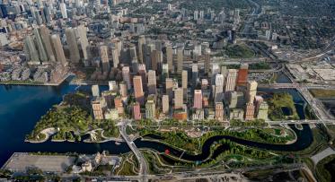
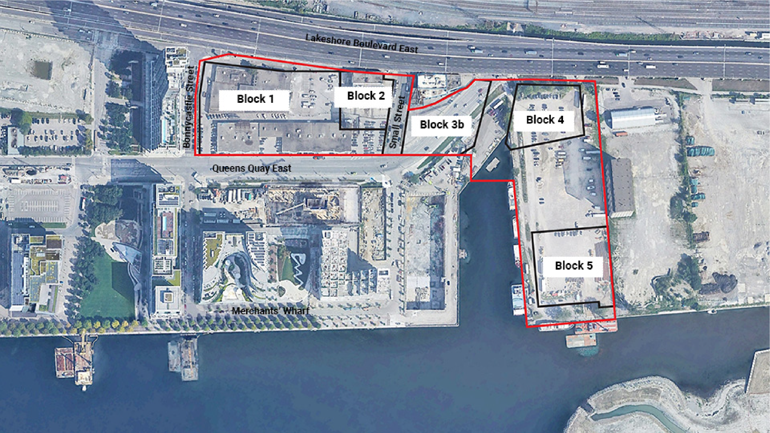
Quayside is the cornerstone in the City’s and Waterfront Toronto’s broader vision for the waterfront, an important connector between communities to the north and west and the future Villiers Island to the south. Situated in the emerging East Bayfront community, an area renowned for its public spaces, such as Canada’s Sugar Beach, Sherbourne Common and the Water’s Edge Promenade, Quayside comprises approximately 4.9 hectares (12 acres), including 3.2 hectares (8 acres) of development sites.
Two distinct but connected projects will transform Quayside from an underused area into a dynamic, inclusive and resilient community. Waterfront Toronto is delivering the area’s infrastructure and public realm (including new streets, public spaces, active transportation infrastructure and other amenities), and local developers Dream Unlimited and Great Gulf Group – together known as Quayside Impact Limited Partnership (Quayside Impact) – are developing the mixed-use community. These two streams of work will ultimately create a seamless complete community and dynamic connection to the eastern waterfront. We’ve recently written about the Quayside development plans, and here we’ll focus on the planning and design of the public realm components.
Waterfront Toronto is working with a consultant team led by WSP and including West 8 and DTAH to deliver groundbreaking public spaces and the enabling infrastructure to service the new neighbourhood. The team is also working with Indigenous design experts at MinoKamik Collective to integrate wisdom from local Indigenous Elders and Knowledge Keepers on plant species and materials selection, and to incorporate traditional and scientific perspectives on forest health and ecology.
These public realm opportunities will help activate the waterfront, meet the needs of residents, celebrate the ecology of the area, and establish Quayside as a destination.
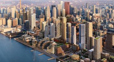
The public realm components at Quayside, led by Waterfront Toronto.
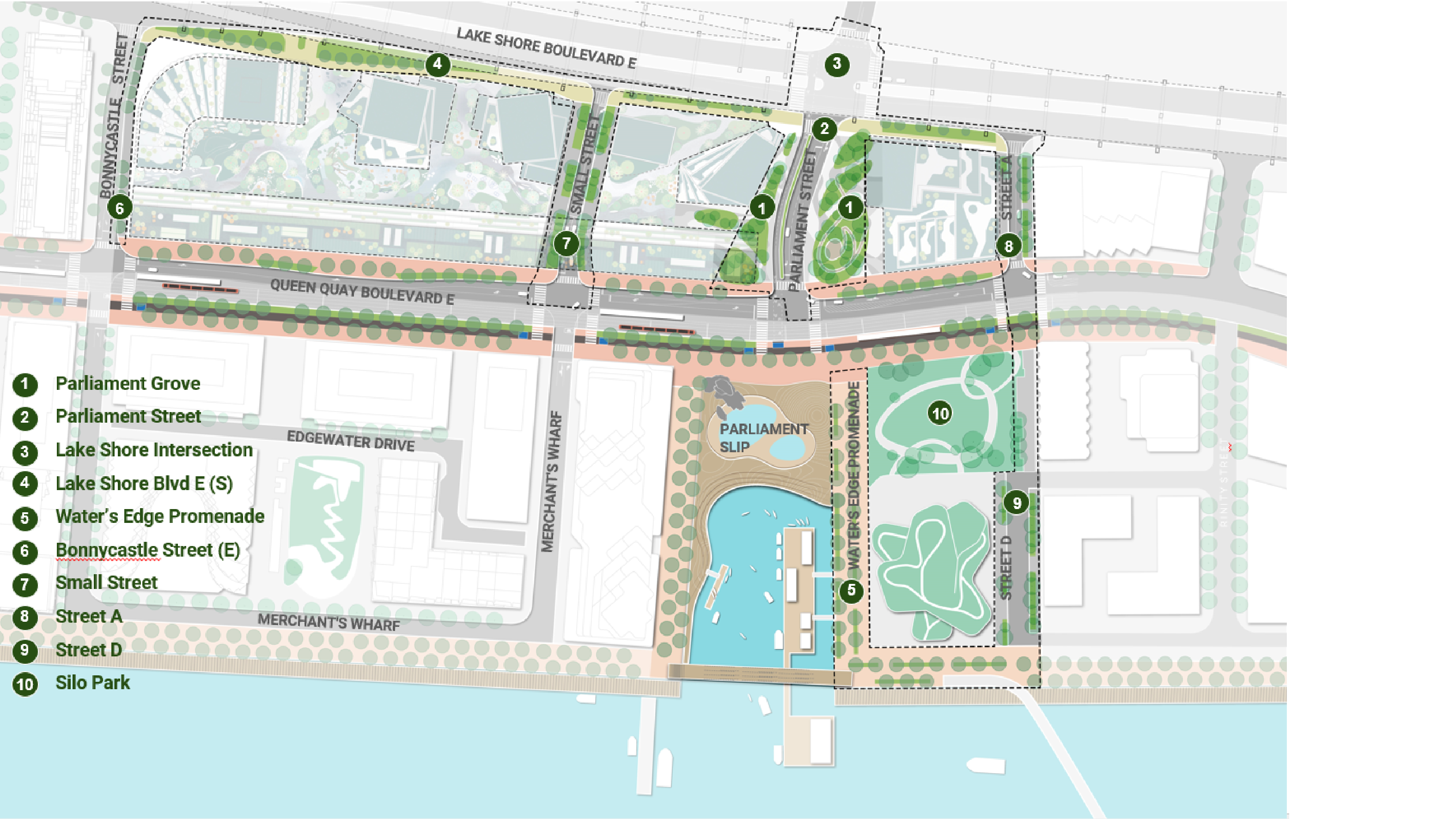
The public realm components include:
- Local streets: A series of local streets will support Quayside. Two existing streets (Bonnycastle Street (east side) and Small Street) will be revitalized, and two new streets (Street A and Street D) will be created – each designed in a manner consistent with others delivered elsewhere in East Bayfront.
- Queens Quay East: To be completed with the iconic red granite mosaic, a lush, planted pedestrian promenade and the Martin Goodman Trail, improving access for walking and cycling.
- Lake Shore Boulevard East (south side): Creating an urban civic boulevard with a distinct continuous landscape identity.
- Parliament Street and Parliament Grove: On either side of the realigned and narrowed Parliament Street will be two green spaces totalling about 0.3 hectares (0.8 acres). The aspiration is for these spaces to provide a lush green transition from Lake Shore Boulevard to Queens Quay and complement the retail and other nearby ground floor amenities.
- Water’s Edge Promenade: The Water’s Edge Promenade, featuring the signature granite mosaic with a double row of trees, provides a continuous public space along the lakefront. Nearly 4.3 kilometers of promenade have already been completed and soon will be extended into Quayside.
- Silo Park (future project): This local park will be 0.4 hectares (1.1 acres) and serve the Quayside and Keating communities. Waterfront Toronto will host a design competition seeking a proposal for Silo Park.
Quayside in context.
The vision for Quayside's public realm is guided by the core principles outlined in the Central Waterfront Secondary Plan as well as goals of the East Bayfront and Keating Channel precinct plans. The eight principles outlined below were informed by public feedback from a public meeting in October 2020 and were then refined by the Quayside Stakeholder Advisory Committee.
Equity: celebrate the cultural diversity of Toronto and equitably welcome all users to these spaces.
Indigenous Placemaking: respect and celebrate Indigenous place-making and the Indigenous relationship to this land.
Accessibility: beyond compliance with accessibility standards, the waterfront should be inviting and barrier-free for users of all abilities and ages.
New Standards for Sustainability and Resilience: green spaces that encourage new innovations, show green infrastructure at work, and improve ecological performance.
Health and Well-being: foster connections between people and nature by maximizing access to greenspace delivered in an integrated way with development.
Activation and Engagement: embrace seasonality and encourage year-round use of public spaces.
Continuity with the broader waterfront: consistent with the vision and design of the public realm elsewhere in the waterfront, and draw people to the lake.
Design Excellence: maintain the standard of design excellence, quality of place, and attention to detail that has been delivered on the waterfront.
Creating a Green Corridor
Landscape designers DTAH and West 8 have worked with the Waterfront Toronto team to translate these principles into a high-level vision for the design: a series of connective green corridors that will extend the urban landscape from the downtown to the water’s edge and ultimately leading to Villiers Island.
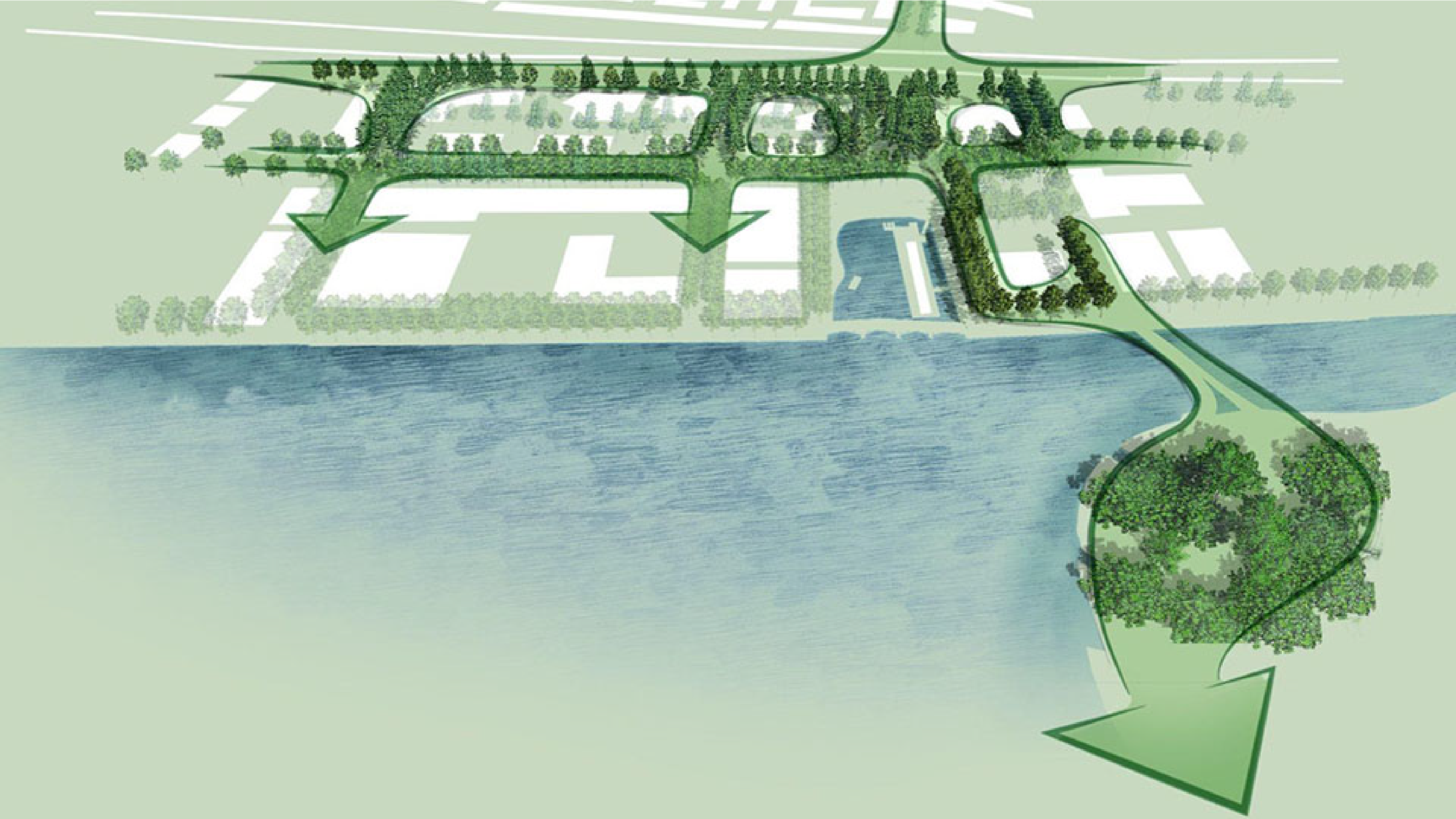
Creating green corridors to the water's edge.
This green corridor is underpinned by a “regenerative urban pocket forest,”. This concept takes into consideration the unique conditions of each area, like the microclimate and the need for proper soil conditions and stormwater retention, and also incorporates cultural history, companion planting, and storytelling stones. For example, integrating the reality of Gardiner Expressway stormwater and ice run-off into the planting strategy for Lake Shore Boulevard and understanding that there’s more potential for storytelling and cultural history along Parliament Grove or the Water’s Edge Promenade.
We are also working with Treaty Holders and Host Nation, the Mississaugas of the Credit First Nation (MCFN), and MinoKamik Collective to design and implement engagement with Indigenous communities on the public realm design.
So, what do the designs envision?
Lake Shore Boulevard will include a series of open planters and trees (where there is no Gardiner overhang). Trees may be hardy Elms and plantings may include shrubs like switchgrass and flowering plants like asters. Final planting selection will be informed by engagements with local Indigenous, environmental and plant culture subject matter experts. The intersection with Parliament Street will be designed with pedestrian and cyclist safety in mind and will include bike lanes. The goal is to create a green urban boulevard that addresses the challenges of the elevated expressway and subsequent pedestrian experience.
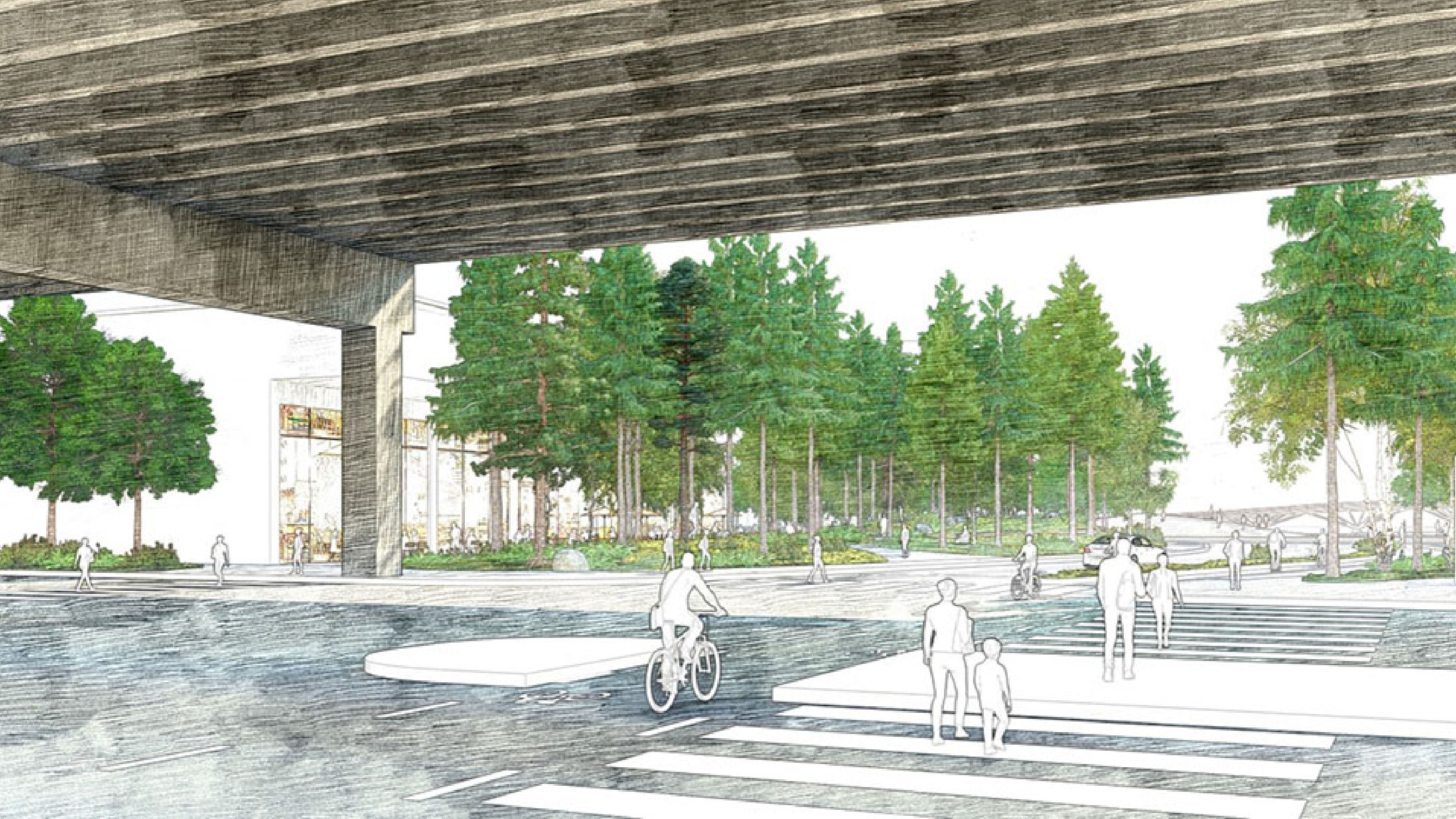
An artist’s rendering of the future Lake Shore Boulevard East and Parliament Street intersection.
As part of the public realm work supporting Quayside, Queens Quay East will be extended to the proposed Street A and a new intersection with a realigned Parliament Street will be created. The first part of this work has already begun with preparation for lakefill at the head of Parliament Slip and the construction of a new dockwall. The public realm design for Queens Quay East will create a consistent and continuous corridor along Queens Quay. The plans will draw from the learnings of Queens Quay West, providing clear and conflict-free pedestrian and cyclist zones as well as new elements like open planters to separate the spaces. The design of Queens Quay East prioritizes active transportation opportunities, including the creation of a transit right of way that will ultimately hold the future Waterfront East LRT (and an interim condition while the LRT project is being finalized).
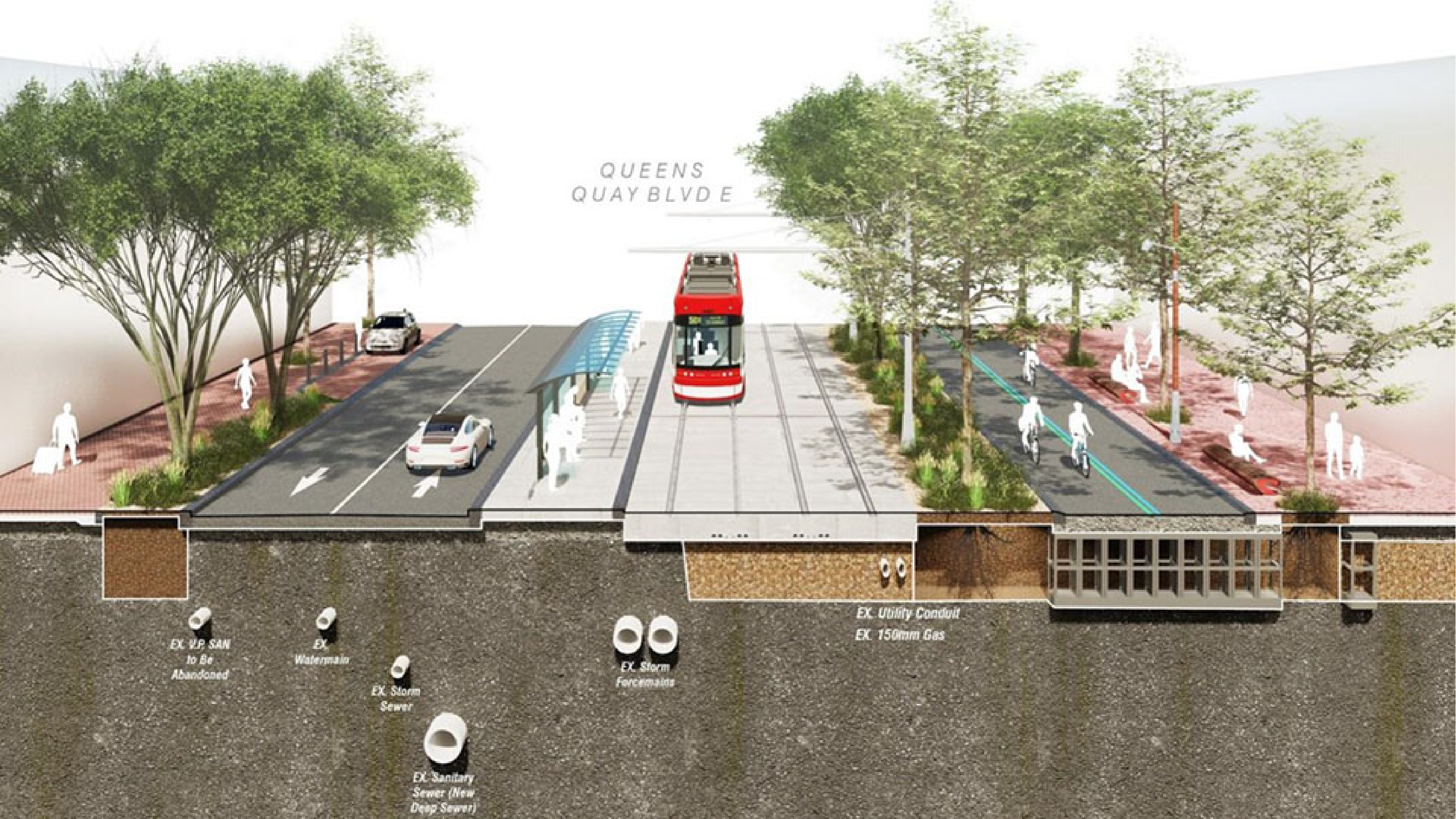
An artist’s rendering of Queens Quay East with the Waterfront East LRT extension.
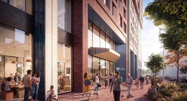
The local streets will prioritize the pedestrian experience and ecological infrastructure with a robust tree canopy, open planters, a stormwater retention system, understory plantings, and bike rings. Rocks will be placed at key locations offering both sculptural interest and impromptu seating areas.
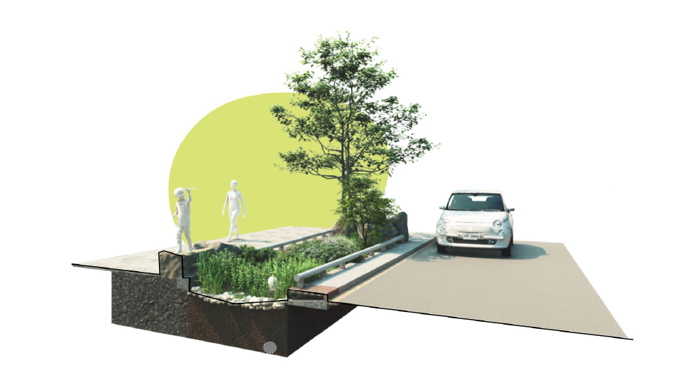
An artist’s rendering of the design for the local streets, including open planters, stormwater retention system, and rocks.
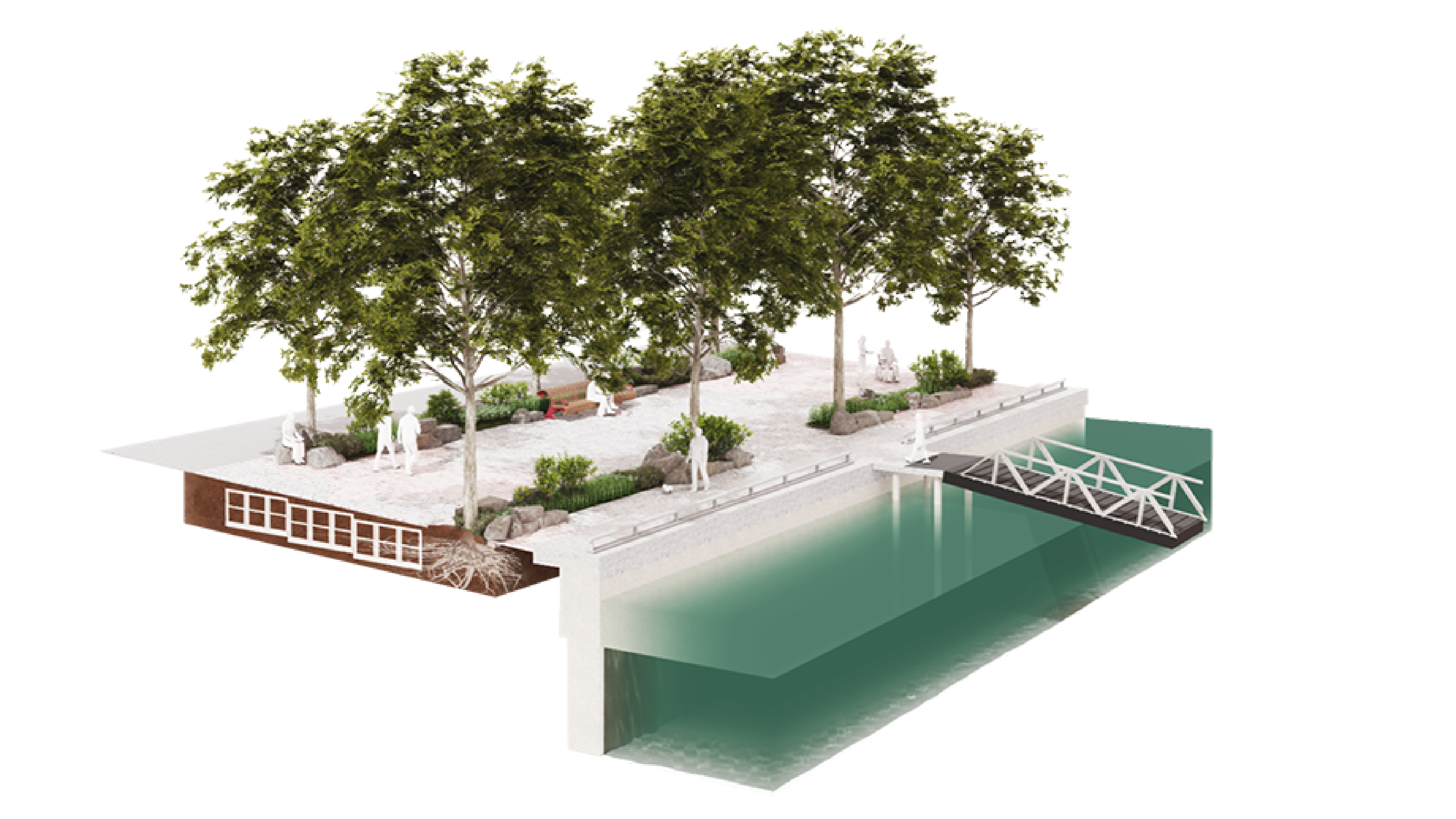
The extension of the Water’s Edge Promenade will continue the signature maple leaf mosaic, double row of trees, signature benches and lighting; however, the approach will evolve and become more “wild” with open planters that include a green understory. The section of the Water’s Edge Promenade on the east side of Parliament Slip will also be the northern foot of the new Keating Channel Pedestrian Bridge, connecting Quayside to the network of trails and parks along the new mouth of the Don River.
An artist’s rendering of the Water’s Edge Promenade, with the double row of trees, open planters, and understory.
Parliament Street be surrounded on either side by green spaces called Parliament Grove. The Grove will be a place of respite amidst the bustle of the city, a place to feel the restorative and healing powers of nature. The design of these spaces will be coordinated with the buildings being designed by Quayside Impact to create a pleasant pedestrian experience and welcoming gateway to the water’s edge.
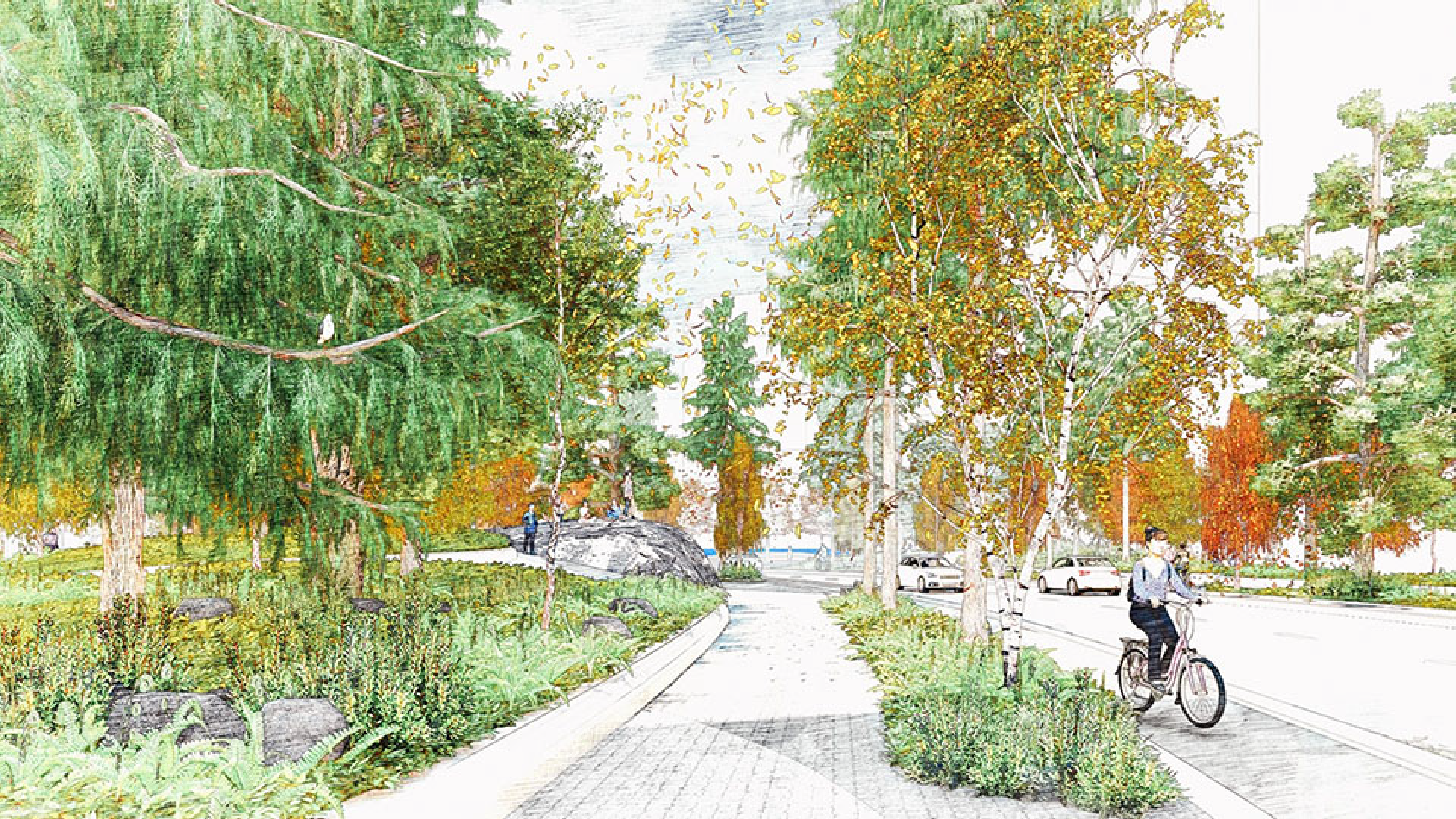
An artist’s rendering of the pedestrian experience going south along Parliament Street.
We’re excited to share this vision with the community and will be hosting a public forum in November 2023 to provide updates and collect feedback. Stay tuned for more information.