Waterfront Toronto unveils technically recommended alternative for revitalizing Queens Quay Boulevard

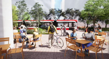
Toronto, March 25, 2009 – After comprehensive study, Waterfront Toronto is recommending that remaking Queens Quay into a grand lakefront boulevard featuring streetcar lanes in the centre, traffic only on the north side and a pedestrian focused space on the south side is the recommended option for transforming the waterfront’s main road.
Waterfront Toronto will officially present the technically recommended alternative and two options for the traffic lanes, one which would have two-way traffic and the other one-way traffic, for public discussion and input tonight. While Waterfront Toronto has a slight preference for the two-way option at this time, further analysis and public input are required before a final option is presented to City Council.“Today we are one step closer to our goal of revitalizing Toronto’s central waterfront area,” said John Campbell, President and CEO of Waterfront Toronto. “From east to west, Queens Quay is the backbone of our waterfront and it will soon become a revered destination not only for Torontonians but the world.”
Transforming Queens Quay by creating a beautiful linear park on the south side of the street that would include a generous new pedestrian promenade and an expanded Martin Goodman Trail was part of the winning design for revitalizing the central waterfront selected by Waterfront Toronto in 2006 after an international design competition.
Prior to making any changes to Queens Quay, Waterfront Toronto and the City of Toronto began a Class Environmental Assessment (EA) process to study the feasibility, impact, and alternatives to the idea. In fact, Queens Quay has been subject to two EAs, one on the revitalization itself and another, done in conjunction with Toronto Transit Committee and the City of Toronto, focusing on planning transit services for the new waterfront development underway in East Bayfront and future communities in the West Don Lands and Port Lands.
The EA process, which has been ongoing for the past two years, has included the examination of several alternative planning solutions for Queens Quay. Each alternative presents a different configuration for a revitalized Queens Quay that has been analyzed and rated against a series of city planning and environmental criteria.
The EA process also includes a thorough and continuing public consultation component and extensive in-depth technical analysis.
Furthermore, rigorous traffic and transit modeling were undertaken to test the feasibility of all of the alternative design solutions.
Results of the EA show that the technically recommended alternative provides the greatest opportunity for creating a world-class waterfront street. Traffic analysis confirms that reducing traffic to two lanes on the north side of Queens Quay is not only feasible in the short term but can also accommodate future traffic demands.
The Class Environmental Assessment process is ongoing and public input is still being sought. The recommended plan incorporating the Preferred Alternative will be identified after we have taken into account public and stakeholder input. It will go to City Council for approval in July.
The revitalization of Queens Quay is budgeted at approximately $192 million which includes all new services and public realm improvements and $150 million for new transit along Queens Quay in the new East Bayfront area.
The first phase of construction from York to Spadina is expected to begin about one year after the completion of the EA. Waterfront Toronto’s goal is to finish construction along Queens Quay by 2012.
The Government of Canada, the Province of Ontario and the City of Toronto created Waterfront Toronto to oversee and lead the renewal of Toronto’s waterfront. Public accessibility, design excellence, sustainable development, economic development and fiscal sustainability are the key drivers of waterfront revitalization.
-30-
Extending the Waterfront East LRT to Villiers Island
COP26 and Local Action: Villiers Island, Toronto’s Climate Positive Neighbourhood