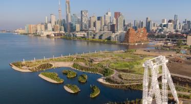
Ookwemin Minising
Toronto has a new island where the Don River meets Lake Ontario. Surrounded by a winding river and overlooking the downtown skyline, Toronto’s new island is a place like no other.
Ookwemin Minising (formerly known as Villiers Island) is a new island born from one of the world’s most ambitious flood protection and river restoration projects: Port Lands Flood Protection. Ookwemin Minising (pronounced Oh-kway-min Min-nih-sing) as the island’s name meaning “place of the black cherry trees” in Anishinaabemowin/Ojibwemowin.
The island is ringed with wetlands surrounding a new park, named Biidaasige Park (pronounced Bee-daw-sih-geh) meaning “sunlight shining towards us” in Anishinaabemowin/Ojibwemowin.
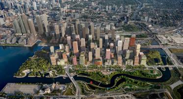
A historic gathering place, the Don River will be at the heart of a new community home to more than 15,000 people and a destination for all to visit and explore.
Quick Facts
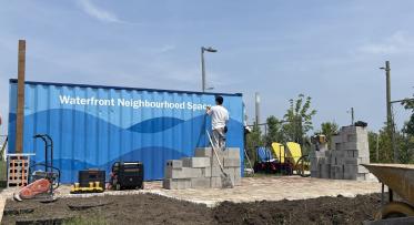
Building this new community
With flood protection nearing completion, we can now get to work on the fundamentals needed to develop the island: the public spaces, streets, stormwater and sanitary pipes, and utility ducts that support the building of new homes.
As we move from planning and studies into designing and building this new community, the streets and public realm and future buildings will take shape, allowing our team to identify the best way to build more homes in this future neighbourhood.
Design starts this summer. Our international consulting team will integrate design for streets and public spaces with a review of the density and built form on the island. Their goal is to design excellent public spaces and streets to create a great neighbourhood; it’s through that lens that they will confirm opportunities to add homes, building on the work completed through a recent Density Study.
Design will also soon start on the remaining section of Biidaasige Park. This is a chance to bring new attractions to undeveloped areas of the island as soon as possible; to begin to make this a city landmark – a place where locals and visitors can experience the wonders of nature, the best of arts and culture, connect with family or take in a show.
Want to get involved?
To stay up to date on opportunities to get involved, sign up for our newsletter.