What Does it Take to Build Great Streets?

New York City’s Times Square has a hustling and bustling street life – but it wasn’t always so people-friendly. What does it take to make truly great streets? (Image by chensiyuan, from Wikimedia Commons.)
In this three-part blog post, we’ll explore a number of factors that contribute to creating vibrant city streets. Part one explores “The Role of Urban Design.” Part two explores how we can “Breathe Life Into Our Streets” and part three looks at “Street Art and the Politics of Public Space.”
POSTED: DECEMBER 1, 2014 I COMPLETE STREETS, INFRASTRUCTURE, DESIGN, PARKS AND PUBLIC SPACES, WALKABLE NEIGHBOURHOODS
By Christopher McKinnon
When we think about what makes great cities, it is often the streets and the public life that inhabits them that come to mind. Sure, we walk in the streets. We bike in them. We ride buses and streetcars and drive our cars in them. But even more than simply being a means of getting from one place to another, streets represent another essential part of life in cities of any size. They are public spaces where we come into contact with our neighbours. They are where we do business and where we hang out. Streets are where we protest, where we demonstrate and where we celebrate. They are that uniquely public place where we come into contact with our fellow citizens. Any discussion of how to build a great city must include a discussion about streets – what makes them work, what experiences we want to have in them and what we can do to make them work better.
At Waterfront Toronto, we spend a lot of time thinking about what will make our streets truly great. Whether we are planning whole new waterfront neighbourhoods – like the West Don Lands – or tackling a dysfunctional street and trying to make it much better – like Queens Quay – our work always begins by looking at what is great in city streets around the world, including what is working here in Toronto. Part of our mandate is to put people first. For us, that means reconnecting Torontonians with their waterfront and creating mixed-use neighbourhoods that will be full of life year-round. When we are designing these neighbourhoods, we take great care to design them on a human scale, to make them walkable, and to make them livable.
The Role of Urban Design
Urban design contributes immensely to city life. We know, for instance, that the most pedestrian-friendly neighbourhoods are also the most desirable and the most livable. Streets and urban environments that are designed at a “human scale” – rather than, say, with automobiles in mind – become places that we want to spend time in. There is a rather nebulous term to describe this, coined by the American urban studies theorist Richard Florida. He calls it “quality of place.” As planners and designers, we are always striving to create this feeling in our neighbourhoods – a feeling of wanting to be there, of accessibility and of opportunity. Urban design has a role to play in creating this feeling. Narrower streets, wider pedestrian spaces with room for outdoor cafes and street furniture, bike lanes (or better yet, separated bike lanes), trees and greenery – all these things can make a street inviting, make it feel like a nice place for strolling, a nice place to just be.
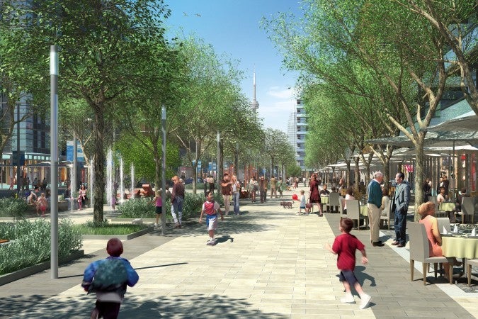
In this artist’s rendering of the Front Street Promenade in the West Don Lands, you can see an inviting streetscape with wide pedestrian spaces, room for outdoor cafes and more.
There are other features of great streets that are impacted by planning and design. For instance, tall buildings that run to the edge of the sidewalk can overwhelm the street level, cast shadows on the sidewalk spaces or even block landmark views that are essential to a city’s character. To address this, we can ensure that tall buildings have appropriate step backs in height – keeping the building’s façade at street level to a more human scale. The right mix of buildings is also important. Blending residential, commercial and retail development within a single neighbourhood helps ensure that our new waterfront communities will be places where people can live, work and play. Walking to work or walking for groceries become more desirable than driving in dense urban neighbourhoods, which also helps contribute to lowering our carbon footprint and making life in the city more sustainable.
Getting Inspired by Great Streets Around the World
There are many great international examples to look at. Las Ramblas in Barcelona is one, an ever-popular strolling boulevard that is a model for street life that prioritizes people. It’s a stimulating mix of commercial activity and leisure – market stalls, street performers, cultural hotspots, and café spaces – a street space that feels alive with people, both locals and tourists.
Watch a walking tour of Las Ramblas on YouTube: http://youtu.be/OWWgsNPj4f8
Another great city to turn to for inspiration is Paris. This European capital is renowned for its culture and street life. A tour on foot of the Latin Quarter reveals bustling streets where pedestrians spill off the sidewalks and into the streets, mixing with cars and motorbikes and cyclists. Like in many European cities, Parisians treat the city streets as an extension of their living room. It’s a sentiment we could do with more of, here in North America.
Watch a walking tour of the Latin Quarter in Paris: http://youtu.be/-uaGIag6PbI
Closer to home, New York City has had brilliant success pedestrianizing Times Square, once a major thoroughfare for vehicular traffic. Initially, local businesses staunchly opposed the proposal – which sought to reduce pollution, increase pedestrian safety and boost retail sales in the area – but a 2009 pilot project began to rally support. Air pollution in the area went down, pedestrian injuries did indeed decrease and businesses were decidedly won over when they saw that it actually increased foot traffic and led to increased sales. Four years later, the new pedestrianized Times Square was permanent and today it’s one of the highlights of any visit to New York.
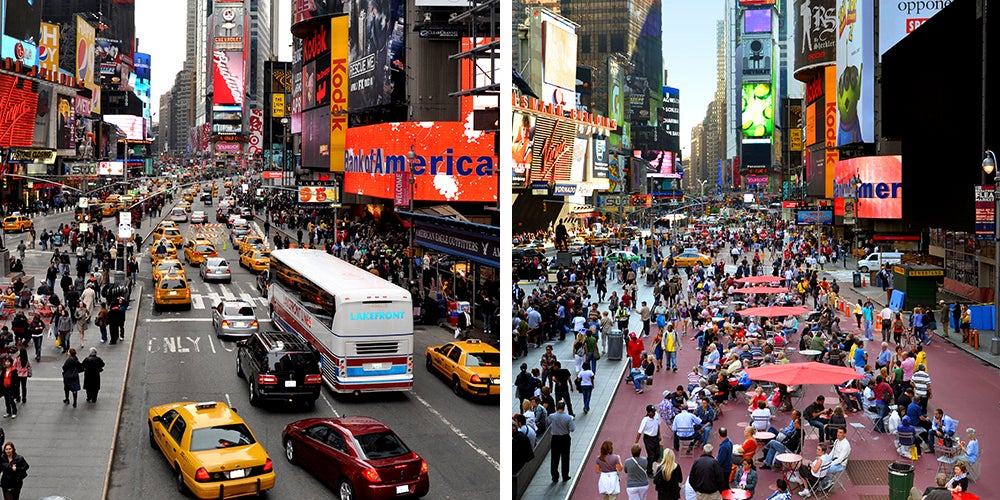
Times Square before and after pedestrianization. (Image credit: New York City Department of Transportation on Flickr)
City officials in New York City fought long and hard to create a pedestrianized Times Square, but the hard work paid off. Today, what was formerly one of the busiest streets for car traffic has been completely handed over to pedestrians. There are now 400,000 people happily and safely walking through the space every day.
Building a Better Street
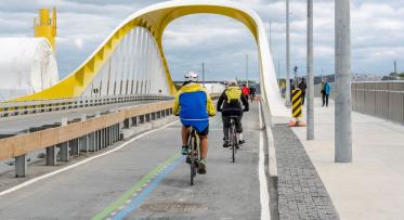
Our work redesigning Queens Quay, that formerly drab waterfront boulevard, takes inspiration from many of these same ideas. The full result will be unveiled next spring, but already you can see it taking shape: Wide pedestrian boulevards, a dedicated trail for cyclists and rollerbladers underway, and healthy new street trees that will soon grow to provide shade and improve air quality. Reconfiguring the vehicular traffic on the north side of the street and creating a better system of turning lanes and laybys for short stops (like buses, delivery vans and taxis loading and unloading) will replace four dysfunctional lanes of traffic with two lanes and still keep drivers moving. The streetcars are now south of the roadway and with new traffic signal timing, public transit will move faster too – meaning fewer people will depend on a car to get to the area.
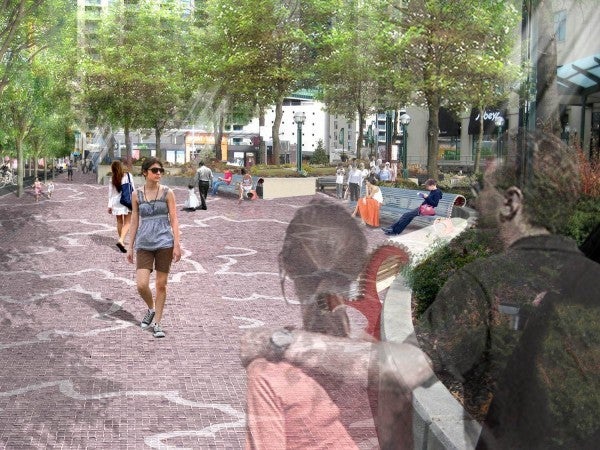
The new Queens Quay opens up the street with new pedestrian spaces, as you can see illustrated in this artist’s rendering.
But most importantly, the space freed up by redesigning the road allows us to create a generous pedestrian promenade and dedicated trail for active transportation like cycling, rollerblading or jogging. New street trees will create a shady canopy effect, to protect the street from the heat of the summer sun. Signature benches and more spaces for programming, street performers and café spaces will make the street – once voted one of the ugliest and least-inviting streets in the world – a truly vibrant waterfront boulevard. When it’s done, it will be a people place – a place where you’ll want to walk, hang out, and enjoy the water’s edge along Toronto’s harbourfront. Check out a photo gallery that shows what the completed street will look like.
In the West Don Lands, Waterfront Toronto was responsible for the master plan and the design of the streetscape. Once again, you can see more inspiration that we’ve taken from great public spaces around the world. The West Don Lands is home to a series of pedestrian-friendly streets called ‘woonerfs’, inspired by the Dutch model of a ‘living street’. Wondering what exactly a woonerf is? They are streetscapes where cars are welcome, but don’t have priority on the road. Cyclists, drivers and pedestrians all share the space. The design forces people to make eye contact with one another as they navigate the space. Cars and cyclists slow down. People feel safer. Kids can play safely in the street. It’s a brand new concept for us here in Toronto, but one that has been successful all over the world. Our first woonerf in the West Don Lands is nearing completion and will be opening soon. Check out this video by the Toronto Star’s Christopher Hume for a sneak peek [LINK].
Other aspects of the master plan for the West Don Lands are also contributing to making the area’s streets great. The new Bayview Avenue extension into the heart of the community is narrower, forcing motorists to slow down, which creates a safer and more inviting street space for pedestrians. The extension of Front Street East into the area is designed with generous pedestrian spaces and a linear park along the street’s north side, ending at Bayview Avenue with a large open plaza and signature public art to act as a neighbourhood landmark.
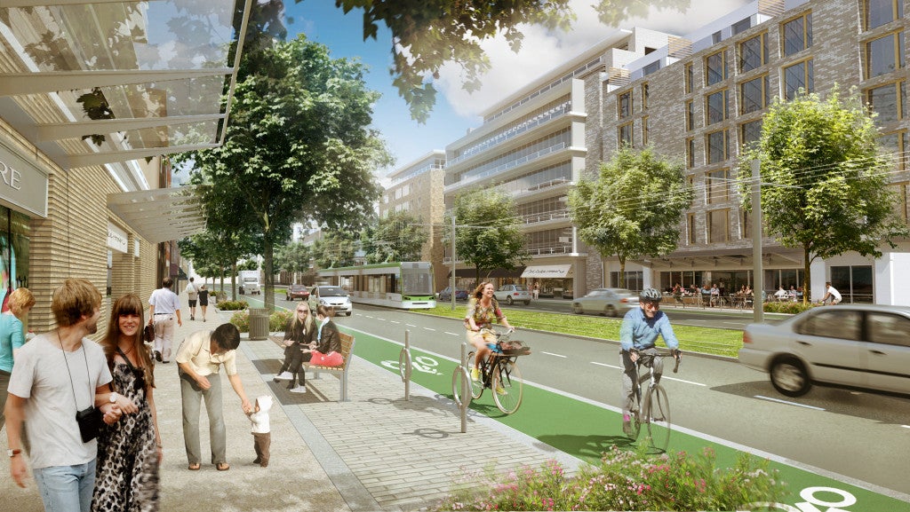
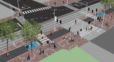
The City of Toronto’s vision for a revitalized Eglinton Avenue puts more focus on the street life and experience of pedestrians and cyclists. (Image from Own Your City, Chief Planner Jennifer Keesmaat’s blog.)
Similar ideas are taking root elsewhere in Toronto. The team in Toronto’s City Planning unit is leading the way with projects like Eglinton Connects, which will see a 19-kilometre corridor of Eglinton Avenue revitalized and redesigned with vastly improved pedestrian and cycling infrastructure. The City’s Chief Planner, Jennifer Keesmaat, explains in this recent blog post just how important it is to shift Toronto’s planning focus to creating Complete Communities in this way.
From the smallest to the largest streets, the importance of designing our public realm to allow for spontaneous, human moments – or even to help inspire them – cannot be overlooked. As Torontonians, we’re thinking a lot about how to make our streets livelier and we’re thinking about the benefits that come with a thriving street life.
Go to Part 2: BREATHING LIFE INTO OUR STREETS [LINK]
Go to Part 3: STREET ART AND THE POLITICS OF PUBLIC SPACE [LINK]
Follow us on Facebook and Twitter – and join the conversation about waterfront revitalization using the #TOtheWaterfront hashtag. Send us your questions. We want to answer them.
Toronto Loves the New Cherry Street Bridge!
What's Happening on Queens Quay West? Improvements for Pedestrians and Cyclists and a Planting Pilot!