Creating a Comprehensive Transit Network on Toronto’s Waterfront

The revitalized Queens Quay West in the Central Waterfront.
POSTED: MAY 27, 2016
BY: MEGHAN HOGAN
Throughout the years, transit planning along the waterfront has been incremental. As a result, there is currently no comprehensive plan for a transit network that can respond to the rapid population and job growth that has come from ongoing waterfront revitalization. With the current and future anticipated demand for transit along much of the waterfront area, there is a need to define a long-term integrated transit solution.
Identifying this solution is no easy task and requires the input of all the Torontonians who live, work and play along the water’s edge. The waterfront is a complex community with varying interests and expectations. But whether the waterfront is a part of your daily commute, or you’re traveling to a waterfront park on the weekend or making local trips around your waterfront neighbourhood, your feedback is important in helping shape the future of waterfront transit.
Earlier this week, more than 200 people participated in a public meeting for the Waterfront Transit “Reset” Study. In partnership with Waterfront Toronto and the Toronto Transit Commission (TTC), the City of Toronto is undertaking this Phase 1 study to establish a clear vision and plan for a comprehensive waterfront transit network, from Long Branch in the west to Woodbine Avenue in the East.
Both evenings began with an overview of the study and background information on past waterfront transit initiatives. The study timeline was also identified, along with the study vision and objectives. Ian Druce, Director at Steer Davies Gleave then presented the preliminary transit concepts and evaluations. Several City Councillors made an appearance at the meetings including Councillor Joe Cressy, Councillor Mike Layton, Councillor Mark Grimes, and Duputy Mayor Pam McConnell.
Watch the full presentation from May 25 here. You can also view the presentation, preliminary evaluations, discussion guide and display boards on our website.
The purpose of this public meeting was to get feedback on the opportunities and constraints along the waterfront, as well as the preliminary concepts and evaluations. If you weren’t able to attend either meeting, you can still let us know what you think by filling in this online survey. Deadline to submit online feedback is Friday June 3, 2016 at 4:59 p.m.
The Study
In November 2015, City Council directed City staff to undertake a Phase 1 Waterfront Transit “Reset” Study. This study is reviewing existing waterfront transit, previously planned waterfront transit initiatives, and current and future transit needs. A range of preliminary transit concepts have been developed and evaluated to help determine a preferred east-west waterfront transit solution that will integrate north/south transit and active transportation, linking people from across the City to the waterfront and its nearby destinations and attractions.
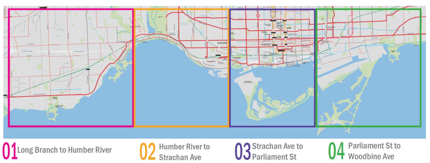
The Waterfront Transit “Reset” study area extends from the Long Branch GO Station and the Mississauga border in the west to Woodbine Avenue in the east, and south of the Queensway/Queen Street corridor to Lake Ontario.
The integrated network solution for waterfront transit is being coordinated with the directions emerging from other major transit initiatives that are currently underway, including Smart Track, Relief Line, Scarborough Transit Planning, and the Metrolinx Regional Express Rail (RER) expansion program.
What’s next?
Once final comments and feedback are received from the public, a City staff report will go to Executive Committee on June 28 for direction on Phase 1 and recommendations for Phase 2. The report will then go to City Council in July.
Phase 2, subject to Council approval, would include feasibility studies; potential environmental assessments or amendments to existing environmental assessments; pursuing implementable short term strategic transit improvements; and advancing a Business Case and pursuing funding opportunities.
Share your thoughts, comments and feedback.
Follow us on Facebook and Twitter – and join the conversation about waterfront revitalization using the #TOtheWaterfront hashtag.
Waterfront Toronto and the City of Toronto open new Aquabella child care centre on Toronto’s waterfront
Tell Us What You Think of the Keating Channel Pedestrian Bridge Design Competition Proposals