Don Mouth Naturalization and Port Lands Flood Protection
The Port Lands Flood Protection Project is about taking action to protect Toronto’s southeastern downtown area. Right now, in an extreme weather event, floodwaters from the Don River would overwhelm portions of the Port Lands, South Riverdale and Leslieville. Our plan is to reconnect the Don River to Lake Ontario by creating a naturalized river mouth. To do this we are embarking on one of the biggest infrastructure projects in Toronto’s history.
Quick Facts
What are we building?
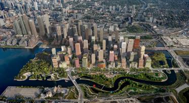
In addition to creating a naturalized river valley—which, in itself, is a historic and significant undertaking—a crucial part of this project involves building new public spaces, roads and bridges and utilities, as well as structures to control water flow and manage sediment and debris.
The work we need to do as part of the Port Lands Flood Protection Project can be grouped into four larger categories: parks, roads and municipal infrastructure, bridges and earthworks/flood protection. A broad description of each of these categories is below.
Parks
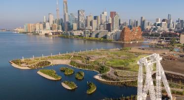
In addition to the naturalized area within the new river valley and Don Greenway, the conceptual design identified 16 hectares of parkland (including parks that will be delivered in later phases of development). This parkland includes parkland along the new river and western edge of the island, which will be designed to include a variety of spaces, some for activities and some for relaxation.
As part of this work, we’re building parkland on the north and south sides of the new river and the southwestern corner of the new island.
Earthworks/Flood Protection
Cherry Street Lakefilling
Lakefilling around Essroc Quay was done to support the realignment of Cherry Street and create the foundation for Promontory Park. We also created coves along the new shoreline where fish can find food and shelter and small boats can launch.
Construction started on Cherry Street Lakefilling in winter 2017 was completed in March 2020.
River Valley Naturalization
We’ve created a new one kilometre river valley as a new outlet through which the Don River can flow. The banks of this river valley will be reinforced to withstand fast-flowing waters during a major storm. The naturalized river mouth will be part of a renewed ecological system of coastal wetlands and meadows.
Don Greenway (Spillway & Wetland)
The new greenspace includes the wetlands and marshes in the Don Greenway. The Don Greenway is a new secondary outlet for the Don River. During very large floods, water from the Don River will flow through the Don Greenway into the existing Ship Channel. In normal conditions, the wetlands in the Don Greenway will be sustained by water from the Ship Channel.
Sediment and Debris Management Area
Sediment and debris need to be removed regularly from the Don River to keep water flowing safely through the river valley, reduce the impact of flooding and maintain safe navigation in the inner harbour. Currently, Ports Toronto dredges mud, silt and larger debris from the Keating Channel. To allow water to flow under the Lake Shore Bridge during a major flood, we need to widen and deepen the Don River upstream of this bridge.
Bridges and Structures
The Port Lands Flood Protection project delivered 4 new bridges across three locations:
- Twin bridges at Cherry Street North. One of these bridges is a future dedicated transit bridge and is not yet in use.
- Cherry Street South Bridge over the new mouth of the river, formerly known as Polson Slip
- Commissioners Street Bridge over the new river, west of Don Roadway
We are also replacing the Lake Shore Boulevard bridge over the Don River. This bridge is being delivered as part of the Lake Shore Boulevard East Project.
Roads and Municipal Infrastructure
We are creating new systems and extend existing systems. This includes utilities like hydro, lighting, gas and telecommunications. A new water distribution network will connect future communities to the existing municipal water mains. A new municipal sanitary sewer network and pumping station will carry wastewater from future communities to the Ashbridges Bay treatment facility. And a new stormwater system will manage rainwater during major storms.
We also realigned Cherry Street. The new street includes sidewalks, a multi-use trail , a future dedicated transit lane and two lanes of vehicular traffic. It was built approximately 50 metres west of the existing Cherry Street to preserve the heritage structures located on either side of the existing street.
Commissioners Street was maintained in its current alignment but dedicated transit and cycling lanes were added. We will build a pedestrian pathway along the southern side of the street, which borders the northern edge of the new park.
Evaluating the Port Lands Flood Protection Project
The three levels of government, along with Waterfront Toronto, make up a four-party mechanism responsible for the administration and governance of the Port Lands Flood Protection (PLFP) project. There are a number of governance committees that allow governments to oversee this work, including the Intergovernmental Steering Committee, Oversight Committee and Executive Steering Committee. Governments also regularly assess Waterfront Toronto’s performance as work on PLFP progresses.