Waterfront Corporation announces winner of Lower Don Lands Design Competition

May 8, 2007, Toronto, ON - The Toronto Waterfront Revitalization Corporation today announced that a team led by Michael Van Valkenburgh Associates, Inc. (MVVA) beat out three other internationally recognized competitors to win the Lower Don Lands Design Competition.
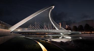
"The winning MVVA design represents a bold innovative approach to naturalizing the mouth of the Don River and transforming a long neglected area into sustainable new parks and communities," said Mark Wilson, TWRC chair. "With this design, the Lower Don Lands stands to become one of the most remarkable places on Toronto’s revitalized waterfront."
TWRC appointed a jury to select the winning design. The jury felt the MVVA design’s big, bold moves impressively integrated the natural and wild elements of the river’s mouth and the Lower Don Lands with urban placemaking, creating a spectacular and compelling vision for the area.
In taking this approach, the MVVA team best addressed the competition’s two key objectives of providing a naturalized mouth and iconic identity for the Don River and creating a comprehensive plan for addressing urban design, transportation, naturalization, sustainability and other ecological issues. Importantly, the team’s detailed understanding of soil conditions and remediation, engineering requirements and landownership issues helped produce a plan that is cost effective and achievable.
"Great cities and great waterfronts go hand in hand" said the Honourable John Baird, Minister of the Environment and federal minister responsible for the Toronto Waterfront Revitalization Initiative. "We have the great city. Now we have the design for the Lower Don Lands."
The other members of the MVVA team are Greenberg Consultants, Inc., Phillips Farevaag Smallenberg, Behnisch Architects, Limno-Tech, Inc., Applied Ecological Services, Great Eastern Ecology, Transsolar, RFR Engineering, Arup, and Totten Sims Hubickiand Associates.
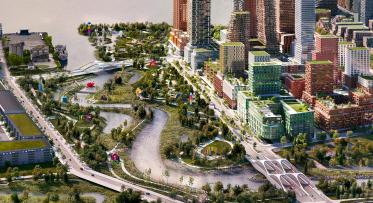
The Lower Don Lands cover the area that runs from Parliament Street east to the Don Roadway and from the rail corridor south to Commissioners Street, including the Don Greenway. The area is a critical link between the new waterfront communities that are emerging in the East Bayfront, the West Don Lands and the Port Lands.
Under the winning MVVA scheme, the Lower Don Lands will be transformed into a sustainable "green" city, a new destination where city, lake, and river interact in a dynamic and balanced relationship – an urban estuary. The mouth of the Don River is the centerpiece of the MVVA design. By moving the river’s mouth from the Keating Channel to Lake Ontario, the scheme reasserts the rivers presence in the city and makes the river an iconic identity for the Lower Don Lands.
"The MVVA outstanding winning design captures the underlying objectives of the waterfront revitalization vision so enthusiastically supported by the McGuinty government: to reclaim the water's edge in the Lower Don Lands area for the people of Toronto and the Province of Ontario as a magnificent public asset," said David Caplan, Ontario Minister of Public Infrastructure Renewal. "This design helps meet the province’s goal of reconnecting Toronto with its waterfront, by developing sustainable, transit-friendly neighbourhoods that exist in harmony with their natural surroundings."
Although the river’s mouth is relocated, the Keating Channel itself remains in tact and will be an important link between the neighbourhoods to the north and south. Envisioned as retail-oriented promenade, the Keating Channel will become an animated destination for city residents and visitors.
"The design competition has been most helpful in coming up with a new vision of the mouth of the Don River," said Mayor David Miller. "It's now much more integrated with the neighbourhoods that surround it and provides plenty of green space for recreation and the enjoyment of nature. I want to congratulate TWRC for assembling four talented design teams who have shown Torontonians that it's possible to transform this long neglected area into a thriving, productive part of the city landscape."
In addition to the generous parks, improved access to the river and lake, and a network of trail connections, the MVVA design provides for new waterfront neighbourhoods that will have strong connections to existing and emerging communities in the East Bayfront and the West Don Lands.
The MVVA design will now inform the naturalization of the mouth of the Don River, flood protection for the Port Lands, precinct planning for the areas between Parliament Street and Cherry Street and in the north end of the Port Lands, and extending Queens Quay from Parliament Street to Cherry Street. The mouth of the Don Naturalization is in progress. Precinct planning and an Environmental Assessment to realign Queens Quay will be underway by the summer.
Members of the jury that selected the winning design were architects Bruce Kuwabara, who chaired the jury, Renee Daoust and Charles Waldheim, photographer Edward Burtynsky and Morden Yolles a structural engineer.
The federal, provincial and city governments established TWRC to oversee and lead the renewal of Toronto’s central waterfront. TWRC currently has a number of major waterfront parks projects underway and development is about start on the West Don Lands, the first new waterfront community.
-30-
Media contact:
Kristin Jenkins, TWRC
Tanya Bevington, TWRC
Public Art Plan Envisions a Free, Outdoor Museum in the Port Lands

New Floating Artwork Features Messages About Water