Governments of Canada, Ontario, Toronto and Waterfront Toronto celebrate the start of construction in Toronto’s Port Lands

January 11, 2018, Toronto, Ontario — Re-naturalizing and flood protecting the Port Lands is a key priority for the governments of Canada, Ontario and Toronto. Building resilient infrastructure in the Port Lands will increase Toronto’s capacity to adapt to climate change impacts and unlock the potential for the Port Lands to be home to the healthy, prosperous complete communities of the future.
Today, Julie Dabrusin, Member of Parliament for Toronto–Danforth, on behalf of the Honourable Amarjeet Sohi, Minister of Infrastructure and Communities, Ontario Minister of Children and Youth Services Michael Coteau (on behalf of Minister of Infrastructure Bob Chiarelli), and Toronto Mayor John Tory joined CEO of Waterfront Toronto, Will Fleissig, to mark the start of construction on the Cherry Street Stormwater and Lakefilling project, part of the Port Lands Flood Protection Project.
On September 14, 2016, the governments of Canada and Ontario and the City of Toronto announced $65 million in infrastructure funding under the Clean Water and Wastewater Fund for the Cherry Street Stormwater and Lakefilling project. This project is advancing as a component of the $1.25 billion Port Lands Flood Protection project.
The Cherry Street Stormwater and Lakefilling project is designed to optimize water and stormwater infrastructure by stabilizing the shoreline under flood conditions, enhancing aquatic habitat, and ultimately, forming part of the proposed Promontory Park. The project will also allow for the re-alignment of Cherry Street, which is necessary for accommodating roads and transit into the Port Lands as part of the economic revitalization of these lands.
The larger Port Lands Flood Protection project will provide critical flood protection through the creation of a naturalized mouth for the Don River and a new river valley, and remediate contaminated soil, unlocking new land for development.
The flood protection project will enable the long-term transformation of the Port Lands into new sustainable communities, including parks, residential and commercial development. The long-term development of the Port Lands will support innovation, deliver affordable housing and jobs, allowing Toronto to grow sustainably, and to meet the challenges associated with this growth.
Moreover, creating a naturalized mouth for the Don River, and establishing new aquatic habitats and functional wetlands, will contribute to Toronto’s environmental resiliency and help reconnect the city to its lake.
Quotes
“The Government of Canada recognizes that flood protection infrastructure is essential to creating better, more resilient and sustainable communities, and a safe and healthy environment. It’s thanks to projects like the Cherry Street Stormwater and Lakefilling project that we will build the Canada of the 21st century and ensure a high quality of life for generations to come.”
Julie Dabrusin, Member of Parliament for Toronto–Danforth, on behalf of the Honourable Amarjeet Sohi, Minister of Infrastructure and Communities
“We know infrastructure is about more than buildings and roads. It’s about improving lives and creating opportunities for the people of Ontario. This project will lead, over time, to increased access to the waterfront and successful new communities where families can thrive and businesses can grow and create new jobs.”
Ontario Minister of Children and Youth Services Michael Coteau, on behalf of Minister of Infrastructure Bob Chiarelli
“The start of construction in Toronto’s Port Lands marks an important milestone in the City’s vision for a vibrant, clean Toronto waterfront. This is the beginning of unlocking the potential of our underutilized waterfront lands, protecting the area from flooding and supporting new places to live, work and play in Toronto.”
Toronto Mayor John Tory
“This is a once-in-a-lifetime opportunity to transform an underused resource in the heart of downtown. Flood protecting the Port Lands will make way for sustainable new communities that deliver affordable housing and job opportunities. This project will enhance Toronto’s resilience to extreme weather, while also restoring a natural environment for all Canadians to explore.”
Waterfront Toronto CEO Will Fleissig
Quick facts
-
In September 2016, Waterfront Toronto received $65 million in tri-government funding for the Cherry Street Stormwater and Lakefilling project through the Clean Water and Wastewater Fund. In June 2017, tri-government funding was committed for the remaining $1.185 billion needed to deliver the full Port Lands Flood Protection project. The three government partners will each contribute one-third of the full cost of the flood protection project.
-
The project will be managed by Waterfront Toronto, a public development corporation established in 2001 by the three orders of government to lead the revitalization of Toronto’s waterfront.
-
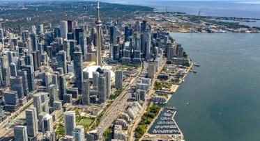
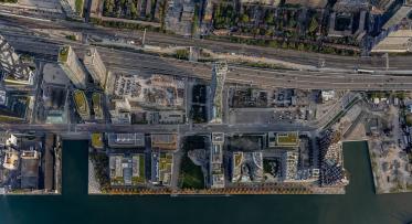
The Cherry Street Stormwater and Lakefilling project is located at Essroc Quay on the south side of the Keating Channel, where it meets Toronto’s Inner Harbour. New land will be created around Essroc Quay to allow for the realignment of Cherry Street and construction of a new Cherry Street Bridge over the Keating Channel. This is part of a plan to better manage stormwater and avoid flooding during major storms. As part of this project, new aquatic habitat will be built. Construction of the Cherry Street Stormwater and Lakefilling project will be completed by the end of March 2020.
-
The Port Lands Flood Protection project is the largest project proposed in the second phase of Toronto’s waterfront revitalization and is one of the most complex urban flood protection projects in Canada.
-
The Port Lands Flood Protection project will take approximately seven years to complete and will be delivered by Waterfront Toronto.
Media contacts:
Brook Simpson
Press Secretary
Office of the Minister of Infrastructure and Communities
Infrastructure Canada
Alex Benac
Press Secretary and Issues Manager
Office of the Minister of Infrastructure
Don Peat
Office of the Mayor of Toronto
Deborah Blackstone
Strategic Communications
City of Toronto
Mira Shenker
Project Communications and Public Engagement
Waterfront Toronto