Your Questions About the West Don Lands Woonerfs Answered

In a recent post on Spacing’s blog, Dylan Reid raises questions about the design of the woonerfs (collectively named ‘Trolley Crescent’) in the West Don Lands. In this response, Andrew Tenyenhuis, one of our project managers, addresses those questions and offers some more context and information concerning this new-to-Toronto street design. (Image from Spacing)
By Andrew Tenyenhuis
In a recent blog post, Spacing’s Dylan Reid raised some questions about the woonerfs we have been constructing in the West Don Lands. A woonerf is a relatively new street type for us here in Toronto, so we are regarding this as a kind of pilot project – but based on the success of these kinds of streets in Europe and elsewhere, we are excited to see them succeed here. If you are wondering where exactly this new street is located, check out this map:
The entire U-shaped Trolley Crescent (highlighted in dark green) runs a little less than 330 metres, from St. Lawrence Street east past the Toronto Community Housing buildings (orange) and courtyard (white), past Lower River Street to wrap around the River City condominiums (purple) and back to St. Lower River Street again. A private woonerf (red) runs between the Toronto Community Housing buildings.
The Dutch word woonerf literally translates to “living streets,” which Wikipedia defines as:
“A street designed primarily with the interests of pedestrians and cyclists in mind and as a social space where people can meet and where children may also be able to play legally and safely. These roads are still available for use by motor vehicles, however their design aims to reduce both the speed and dominance of motorised transport.” – from Wikipedia
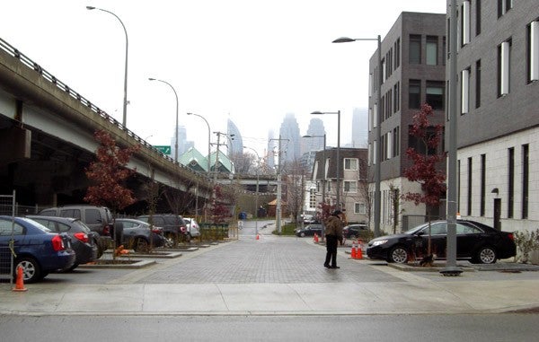
Dylan points out that at the moment our woonerfs do not seem to be functioning well. He concludes: “The southern portion of Trolley Lane, […] is in fact primarily a space for cars: a rear lane, a parking lot, and the access point to an underground garage.” Looking at the pictures that illustrate his post, you would tend to agree – but there’s more going on here.
For starters, while there are cars parked on the street in the pictures that illustrate Dylan’s post, this is not actually a parking lot. Bike rings and other street furniture fixtures will be installed on Trolley Crescent this spring. When these elements are installed, parking will no longer be possible, as depicted in the photo below. Our design will actually prevent on-street parking. Instead, the woonerfs will encourage casual pick-ups and drop-offs. This is more consistent with the types of limited, local motor vehicle traffic you would expect on a woonerf.
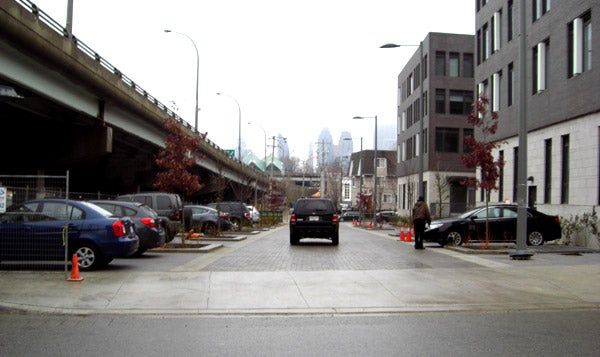
Though there are a lot of cars parked here in this picture, this is a temporary condition. It is not a parking lot. Bike rings and other fixtures will be installed soon – and once they are there will be not be space for parking like this on Trolley Crescent and cars parked illegally will be ticketed or towed. (Image from Spacing)
Furthermore, Dylan’s post implies that the street’s main purpose is for accessing those parking garage spaces, but that assumption is not entirely accurate. There are garage entrances on our woonerfs, but this does not make them any less of a woonerf. These public streets were intended to keep cars traveling slowly enough as to not greatly exceed the the walking pace of a pedestrian until they exit the woonerf and drive onto a more typical street. The building parking garages themselves hold relatively few parking spaces. The three TCHC buildings, for example, have only 75 parking spaces for their combined 243 units. The woonerfs are intended primarily as pedestrian spaces; cars are “guests” allowed to reach those garage spaces. Other than some residential and building visitor traffic, the only other motor vehicles that will have reason to use these streets are for weekly garbage and recycling collection. The traffic on Trolley Crescent will predominantly be people walking, not driving.
The width of the woonerfs is wider than you might see in a traditional Dutch woonerf, as Dylan rightly points out. We would have liked them to be narrower, but underground utilities and emergency vehicle access prevented that. We had to use these lanes as rights-of-way for buried utilities (gas, hydro, etc.). These utilities stipulate in Ontario how much room they require between them and other street elements (street trees, etc.). We also had to allow for the minimum requirements for unobstructed access for emergency services. City ladder fire trucks are large and require space to extend their outriggers. Other design features, however, still promote pedestrian priority on this street – absence of raised curbs (impedance of access across the whole street), textured paving (alerting the driver through the vibration that they have entered a different zone), raised sidewalk entrances (cueing to the driver, again, that the Woonerfs are in a slower speed zone), and the presence of pedestrians and cyclists traveling in all areas of the street (sides and middle). Adding to these design features, the woonerfs themselves are quite short – less than 95 metres in each section before you must cross an intersection or make a 90-degree turn. This further limits vehicle speeds.
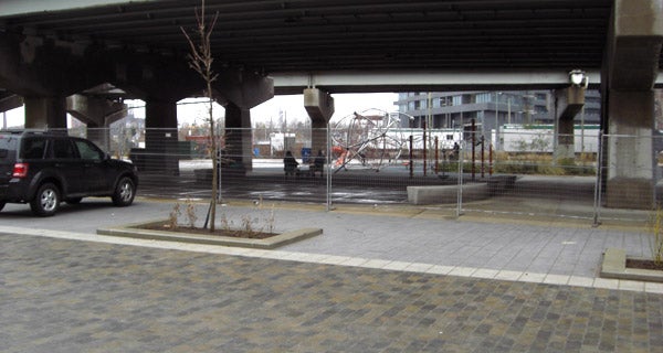
A fence dividing Underpass Park from the neighbouring woonerf remains in place until the City of Toronto assumes responsibility for the street, at which time the fence will come down. (From Spacing)
With respect to the fence running along the edge of Underpass Park, Dylan says in his post:
“The space is considered dangerous enough that the Underpass Park playground beside it is currently fenced off. It’s not clear what will happen in the future, although some separation will be necessary to keep cars from driving into the park.”
In fact, the fence is still in place because Trolley Crescent has not yet been assumed by the City of Toronto and requires separation for reasons of liability. Once the street is assumed, the fence will come down and this will be a convenient walking route for TCH residents from their courtyard (at the centre of the three buildings) to Underpass Park.
Finally, it is worth looking at the example of Market Street’s new design mentioned in the Spacing post (reconstructed between The Esplanade and Front Street). It certainly bears some of the hallmarks of a “shared street,” if not a woonerf per se. It is an interesting comparison to Trolley Crescent in terms of how street design can encourage traffic calming, pedestrian uses and a feeling of “shared space.” There are two key differences between Trolley Crescent and Market Street that are worth bearing in mind, however. First, Market Street is a through-street that serves a larger volume of more diverse traffic and has many more destinations, both commercial and residential. Second, it has on-street parking and bollards that further separate vehicles from pedestrians/cyclists. Trolley Crescent, by contrast, is not a through-street nor is it divided by bollards and on-street parking (the latter making Trolley Crescent a true woonerf). Further, the only destinations on the street are the three driveways to the residences. Residents and visitors of the residences will almost be the exclusive users of Trolley Crescent. The volume, speed, and types of traffic on these two streets will be very different and this will create a unique character and atmosphere on each of them.
In short, it is still early to judge Trolley Crescent. Once the woonerfs are completed with the remaining street trees, bike racks, and street furniture – and once all the new residents have moved in and all the construction in the area has completed – we believe you will see something highly unique and successful in the West Don Lands.. We fully expect these to be shared spaces where pedestrians and cyclists have priority and motorized vehicles are guests.
Have a question about waterfront revitalization? Ask us. You can join the conversation using the #TOtheWaterfront hashtag and follow us on Twitter and Facebook.
Watch this video to see how the waterfront is changing. Even better, come down and see for yourself what’s happening on the waterfront.
Want to know more about woonerfs?
Check out Chris Hume’s video on thestar.com or “What exactly is a woonerf, anyway?” from the nationalpost.ca.