Waterfront Toronto presents a revolutionary vision of sustainability for the Lower Don Lands and details of the areas first community

Toronto, May 7, 2009 – Waterfront Toronto unveils detailed plans for transforming the Lower Don Lands, a 125-hectare (308-acre) industrial area located south of the rail corridor in the east end of Toronto’s harbour, into new sustainable parks and communities.
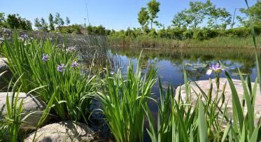
As part of waterfront revitalization, Waterfront Toronto has taken bold and innovative approachs to naturalize the mouth of the Don River and to transform the Lower Don Lands, a critical link between the new waterfront communities emerging in East Bayfront, the West Don Lands and the Port Lands.
The plans would see the mouth of the Don River moved from its current location at the Keating Channel near the Don Roadway to Lake Ontario on the eastern side of Toronto’s inner harbour. The river would be re-routed through the middle of the Lower Don Lands between the Shipping Channel and the Keating Channel. This will result in the Don River once again becoming a major feature of Toronto’s waterfront and the centerpiece of new mixed-use neighbourhoods and parks and green spaces in the Portlands.
Waterfront Toronto’s plans were developed through a comprehensive Environmental Assessment (EA) process which has included the examination of several alternative planning solutions. The plans are rooted in planning designs developed by Michael Van Valkenburgh Associates (MVVA) as part of the international design competition for the Lower Don Lands held by Waterfront Toronto in 2007.
“What excites me about the plans for the Lower Don Lands is that it provides a new type of neighbourhood for Toronto, says Waterfront Toronto President and CEO John Campbell. “The plans are models for new sustainable communities. They will create a new destination for Toronto where the city, lake and the river interact in a dynamic and balanced relationship – an urban estuary.”
“How often does a city re-locate the mouth of a river, restore the river to a condition that nature would applaud, create a new park along its edges and build the most carbon neutral new urban neighbourhood possible?” says Michael Van Valkenburgh, Principal of MVVA and the consultant team lead for the project. “The Lower Don Lands project proposes an approach to an urbanized river which no city has taken before.”
Creating sustainable communities is a fundamental objective for Waterfront Toronto. To ensure that its plans for the Lower Don Lands were based on innovative and multifaceted approachs to sustainability, Waterfront Toronto created an integrated design process that utilized the expertise of landscape architects, urban designers, hydrologists, ecologists, climate engineers, environmental specialists, sustainability specialists, and economic advisors.
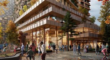
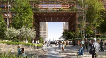
The Lower Don Lands plans take a holistic approach through the introduction of urban development, native ecologies, and public infrastructure in the transformation of the area into vibrant, mixed-use communities lined by generous promenades and traversed by a series of bridges for vehicles, transit, cyclists, and pedestrians.
As part of Waterfront Toronto’s broader sustainability goals, the Lower Don Lands plans prioritize transit as a mode of transportation creating dedicated space for high frequency light rail transit. In addition, extensive multiuse trails in the area will act as major connecting links with the Don Valley Trail system, the Don Greenway, and the Martin Goodman Trail, maintaining continuity and enhancing the public realm.
Sun and wind movement studies have been used to shape the orientation of buildings and street blocks in the plans for the Lower Don Lands. This will not only further the development of an energy efficient indoor building climate but will also provide for a more comfortable experience in the public realm by maximizing the natural cooling effects of summer breezes and shade while offering protection from winter winds.
“By working with and understanding climate, a more comfortable and sustainable city can be created at less cost to the environment,” says Campbell.
The plans for the Lower Don Lands envision a mix of 75 percent residential and 25 percent non-residential space.
The first community to be developed in the Lower Don Lands will be the Keating Channel neighbourhood, the area that runs from East Bayfront to the Don River and from the West Don Lands to Villers Street. The precinct plan for the area consists of 25 blocks that will feature a variety of built-forms and architecture that support a diversity of experience and use.
The public will have an opportunity to review the plans, ask questions of the design team and provide input at a public meeting on Saturday May 9 from 10 a.m. to 3 p.m. at St. Lawrence Hall, 157 King Street East.
At the meeting Waterfront Toronto will present detailed plans for the Lower Don Lands and a draft precinct plan for the Keating Channel neighbourhood. Toronto and Region and Conservation, the agency assisting Waterfront Toronto with the EA for the new mouth of the Don River, will present the new river alignment and innovative flood protection strategies for the Don River.
"We are pleased to partner with Waterfront Toronto, their design team led by Michael Van Valkenburg Associates, our EA consultant team led by AECOM, and the City of Toronto in developing this concept design for the naturalized mouth of the Don,” said Brian Denney, Chief Administrative Officer, Toronto and Region Conservation. "This project integrates our key goals of naturalizing the mouth of the Don while removing the risk of flooding to the most vulnerable area in our jurisdiction.”
The original design for the Lower Don Lands upon which current plans are based has already received recognition from the international design community. Waterfront Toronto together with MVVA received the 2008 Royal Architectural Institute of Canada’s Sustainable Development Award for the concept design of the Lower Don Lands. The project has also won the American Society of Landscape Architects 2008 Honor Award in Analysis and Planning.
The Government of Canada, the Province of Ontario and the City of Toronto created Waterfront Toronto to oversee and lead the renewal of Toronto’s waterfront. Public accessibility, design excellence, sustainable development, economic development and fiscal sustainability are the key drivers of waterfront revitalization.
-30-
Media Contact: Sheri DeCarlo, Waterfront Toronto
Embracing biodiverse landscapes for a better planet
Something big and ambitious is happening at Quayside