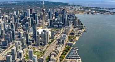
Getting to Work on ‘Villiers Island’
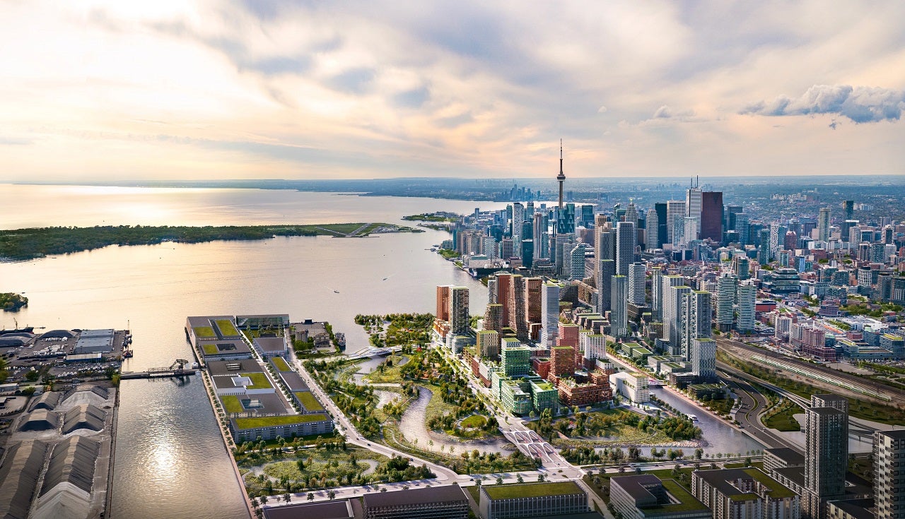
This artist's rendering shows how buildings on the new island could look.
POSTED: JUNE 27, 2024
In this blog:
- This June, Toronto City Council approved amendments to the 2017 Villiers Island Precinct Plan that will allow for more housing on the island, including affordable housing.
- The amendments to the 2017 plans are just that: plans. The next step is a design exercise that will deliver on the island’s potential .
- In spring 2024, the City of Toronto, CreateTO and Waterfront Toronto hosted public meetings and received over 100 questions. We've undertaken to answer the most frequently asked questions here.
- A design process is starting later this year that will create an opportunity for the ideas we’ve heard to be explored. We’re excited to dig deeper into some of your feedback and work with you to create a community that will set new standards for sustainability, innovation, accessibility, design excellence and Indigenous place-keeping.
Toronto City Council has adopted amendments to the 2017 Villiers Island Precinct Plan
With the densities approved by City Council in June, we can work with the City and CreateTO to deliver as many as 2,700 affordable rental homes.
This is a critical project if we want to grow Toronto’s downtown sustainably and help address the housing crisis. If our current schedule holds, people can move into new affordable and rental housing by 2031 as part of a first development phase.
Along with amendments to the Precinct Plan, Council approved zoning to enable the development of a mixed-use neighbourhood in this former industrial zone. These amendments include flexibility that will allow for some changes once the streets and public realm are designed.
Ambitions for this community are high. It should set new standards of sustainability, innovation, accessibility, design excellence and Indigenous place-keeping that can serve as a model for future developments across the eastern waterfront.
With park construction and flood protection nearing completion, the next step towards realizing this vision for the Island is the design and implementation of all the enabling local infrastructure to deliver a complete operating system, streets, public squares, and promenades needed to support development. This will begin as a design exercise, focused on delivering on the island’s potential to be walkable, human-scale, active and sustainable.
The process, which will start later this year, will create an opportunity for the ideas we’ve heard to be explored.
This work will include:
- Developing an overarching vision and landscape framework for the Island, including a connected network of walkways, public spaces, parks and plazas, and streets
- Identifying opportunities for climate positive design across all elements
- Confirming the road network and the requirements for each segment of roadway in the network – including evaluating all right-of-way widths and mode splits
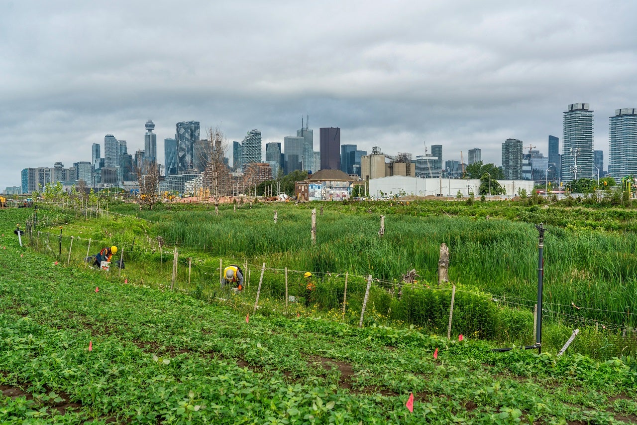
Port Lands Flood Protection unlocks post-industrial land near downtown to create new neighbourhoods, including ‘Villiers Island.’ This view looking west over the new greenspace shows how close to Toronto’s downtown this natural ecosystem is.
Beyond the beauty of the restored natural environment, Port Lands Flood Protection has allowed us to build foundational infrastructure for this island community. The Martin Goodman Trail and Lower Don Trail extend through the island and we’ve set aside space for the Waterfront East Light Rail Transit, expanding opportunities for nonmotorized travel between existing parks and neighborhoods. New parklands will allow visitors and residents to immerse themselves in the urban waterfront. The parks and river valley set to open in 2025 will be a unique ecological asset to the future island residents, as well as people living and working in nearby communities like Quayside, the Keating Channel Precinct, the McCleary District and East Bayfront. They’ll also be a destination for people from across the region – and likely the world. This is Toronto’s new landmark parkland.
Your questions answered
In 2023, the project team of the City of Toronto, CreateTO, and Waterfront Toronto began a density study for Villiers Island in response to direction from Toronto City Council to increase the density by at least 30% above the 2017 Precinct Plan. Participants at a June 2023 public meeting examined:
- The relevance of the 2017 plan’s guiding principles, and
- Potential changes to the building scale and heights in the 2017 plan.
In spring 2024, the project team reported back on the outcomes of the density study and some proposed amendments to the 2017 Precinct Plan.
We received hundreds of questions and comments over the past few months at public meetings and via social media. We’ve answered some of the most frequently asked questions here.
Q: Why does this plan make so much space for cars? Why are we building such wide roads?
A: In planning language, a right-of-way (ROW) refers to all the public space between buildings. It includes the roadway for vehicles, transit lanes, sidewalks, bike lanes, medians, planters, and buffers. While the ROWs for the recently opened New Cherry and Commissioners Streets are around 40-metres, the space for cars is 6.6 metres, which is two lanes. At some locations, this expands by 3 metres for turning lanes. The rest of the ROW is dedicated to separated transit lanes, cycling, walking and landscaping. These streets are major routes on and off the island, so they have space for all modes of transportation.
The future ROWs on the Island are planned to be between 18-20 metres, some with one vehicular lane; others with none. Some of the street cross-sections you may have seen show extra space between the sidewalks and building faces, called setbacks. These have been eliminated, still leaving enough space for amenities like street furniture and bikeshare stands and activity created by retail.
An upcoming design process will take a more detailed look at the cross sections for these streets and the overall ROW. Through that process, some of what has been shown is likely to change. The design work that is still to come includes:
- Seven rights-of-ways that make up the interior transportation network
- Public spaces like parks and plazas
- The buildings themselves
- The Keating Channel urban boardwalk
That design process will:
- Confirm street cross-sections (i.e., what type of traffic each right-of-way will accommodate and how big each of those spaces will be)
- Identify materials for roads, sidewalks, buffers, etc.
- Examine how the right-of-way integrates with the buildings
Q: Can we change this plan once it is approved by Council?
A: The Precinct Plan outlines the streets and blocks for this new neighbourhood. The locations and designs for New Cherry and Commissioners Streets were determined through the Environmental Assessment process, while the general locations of the local streets were established through subsequent studies and the Precinct Planning process. This plan is the foundation for a new neighbourhood on Villiers Island, and it’s a starting point, not the end point. The Zoning Bylaw City Council passed this summer will specify the Floor Space Index (FSI) per block and a large building envelope within which buildings can be designed. FSI is the relationship between the total amount of usable floor area and the total area of the property, or development block, on which it stands. Focusing on FSI rather than Gross Floor Area (GFA) creates more room for the GFA permissions for a block to adjust if the block’s boundaries are moved in response to future right-of-way and public realm design work. While the foundation of the plan won’t change, there is ample opportunity for changes as development proceeds over the next several years.
Q: How much, and what kind, of affordable housing will be built? What about supportive housing? How is affordable housing defined?
A: The updated precinct plan proposed approximately 2,200-2,700 affordable rental housing units on the island, depending on the size and number of family-sized units. This is an estimate that could change depending on the size of the units. Currently, it is based on larger unit sizes overall to accommodate families.
There are different options for providing affordable housing, including potentially co-op, seniors, or supportive housing, and the strategy for Villiers Island has not been determined yet. As part of this work, we will ensure new development is guided by enabling Innovative partnerships; including advancing partnerships with Indigenous communities to ensure a complete community process.
Q: Where were the opportunities to add more density?
A: The Density Study identified the greatest opportunity for density on the western and central blocks, close to future transit stops. Additional density is also being planned along the Keating Channel Promenade, which will be an active retail and commercial strip. Design refinements may lead to more density than what's currently approved and, at the direction of Council, the project team of City, CreateTO and Waterfront Toronto will also explore the possibility of a mixed-use residential building on the Essroc site west of Cherry Street.
While there’s no established formula or analysis that determines exactly how much density can or should be added to a neighbourhood, the project team considered several due diligence studies. Many of the factors that were considered were examined with the new island as part of a larger development area, with more than 100,000 future residents to come over the next several decades.
The factors include:
Minimizing shadow impacts on new habitats and wetlands returning to the Don River. This limited density on the east blocks.
Infrastructure, specifically transportation and municipal services. Transportation planning and engineering consultants, working with City, Waterfront Toronto and CreateTO staff, evaluathed the 60% density increase on Villiers Island. Analysis determined that Villiers Island will experience transportation and transit congestion, reflective of its projected growth. The increase in density at full buildout requires the planned pedestrian, cycling, and transit network, including the proposed Waterfront East Light Rail Transit, and the nearby Corktown Ontario Line and combined East Harbour Ontario Line and GO Station serving Villiers Island.
Municipal servicing. While we may not see these infrastructure systems as a hard limit on growth, they are important to consider and plan for, as we must understand the cost implications of any changes. There is also planned downstream infrastructure that receives flows from a broader geography, including Villiers Island, East Harbour, South River, and McCleary Precincts, and which will have capacity limits.
Flight Paths. City staff have consulted with PortsToronto, NAVCanada and Transport Canada on airspace issues around airports, and specifically on the Villiers Island Precinct Plan. At this point in time, City staff have noted that additional tower heights beyond what are being recommended on the Island's western blocks are not supported.
Q: Can you increase the size of the parks more?
A: The Island is almost 40 hectares, almost half of which is natural greenspace and parks. Thanks to Port Lands Flood Protection, the Island sits next to an extension of the Don Valley system: the new river valley and associated wetlands, habitats and parkland create almost 17 hectares of open greenspace.
While this natural green space and destination parkland serves a much larger area than just the island community, residents will benefit from it. Think of it as similar to neighbouhoods that are close to the Don River valley ravine system north of the Port Lands. It will be a valued ecological resource for people who live nearby. In addition to that natural river system, the island community is planned to have just over two hectares of local parks. These will include amenities that serve the local school and community members.
Q: Why are the amenities located where they are? How will you make sure the community has strong retail and service offerings?
A: The locations of community amenities shown are still conceptual, and their location will evolve with the plans for the island.
While the Island feels remote right now, as the entire area transforms, the demand for facilities and services will grow, creating a more attractive location for retailers and service providers throughout the Port Lands and surrounding areas.
Answers to questions about specific amenities are available will be in the full Q+A document that will append the meeting summary.
Sign up for our monthly newsletter to learn about future public engagement opportunities, including those related to the public realm on the new island.