Don Mouth Naturalization Becomes a Reality

POSTED: AUGUST 23, 2017 I ECONOMIC DEVELOPMENT, INFRASTRUCTURE, SUSTAINABILITY, PARKS & PUBLIC SPACES, TRANSPORTATION
BY: MIRA SHENKER
This June, we announced $1.25 billion in tri-government funding for Waterfront Toronto to naturalize the mouth of the Don River, provide flood protection and lay the groundwork for new communities. This project, officially called Port Lands Flood Protection and Enabling Infrastructure (PLFPEI), will be a vital part of helping Toronto grow in a sustainable way. This $1.25 billion includes the $65-million in tri-government funding announced in September 2016 for Cherry Street Stormwater and Lakefilling (CSLF), a component of the larger PLFPEI.
This funding will allow us to create two new outlets for the Don River, a 1,000-metre river valley and greenway that will safely convey flood waters into Lake Ontario. The project includes new roads, bridges and services, as well as 29 hectares of naturalized area in the river valley, new parks (River Park North and South and Promontory Park South) and 14 hectares of aquatic habitat.
The flood protection offered by the new, naturalized Don River valley, along with new infrastructure, public spaces, wetlands and trails will create an area the size of downtown Toronto where people can live, work and play.
What happens now?
Port Lands Flood Protection and Enabling Infrastructure is comprised of 21 components.
Port Lands Flood Protection and Enabling Infrastructure (PLFPEI) will take seven years to build. The plan is already in place and vetted through a rigorous due diligence process. That means we’re positioned to start detailed design right away. Because we received some funding for Cherry Street Stormwater and Lakefilling (CSLF) already, detailed design for CSLF started in September 2016 and is almost complete, with construction slated to begin this fall.
We’re now working with the Federal, Provincial and Municipal governments on agreements that will allow additional funds to flow over time. We’re also completing an agreement with the City of Toronto that will provide the funds needed to start detailed design work on more of the project components.
We are in the process of procuring the lead contractor on this project, who will act as our construction manager on both the CSLF project and the broader flood protection project.
Construction on the Cherry Street Stormwater and Lakefilling (CSLF) Project
Construction in the Port Lands will start this fall with the creation of a new landform around the existing Essroc Quay. The landform will create room to re-align Cherry Street and build a new, higher bridge over the Keating Channel to better withstand and accommodate floodwaters. This new landform will also be the base of the future Promontory Park North. In addition to lakefilling, creating this new landform involves the design and construction of confinement berms, rock armoring and dockwall structures. We’ll also build new aquatic and terrestrial ecological habitat.
We’ll form a Construction Liaison Committee (CLC) this fall before construction begins. Once we have details about construction staging and schedule, we will share them through the CLC as well as on our website and in construction notices. We’ll circulate regular communications related to construction activity and traffic impacts. Access to destinations in the Port Lands, like the Cherry Beach Sports Fields, will be maintained.
Sign up here for our newsletter, which will include updates on this project.
More information about the past and future of the Port Lands
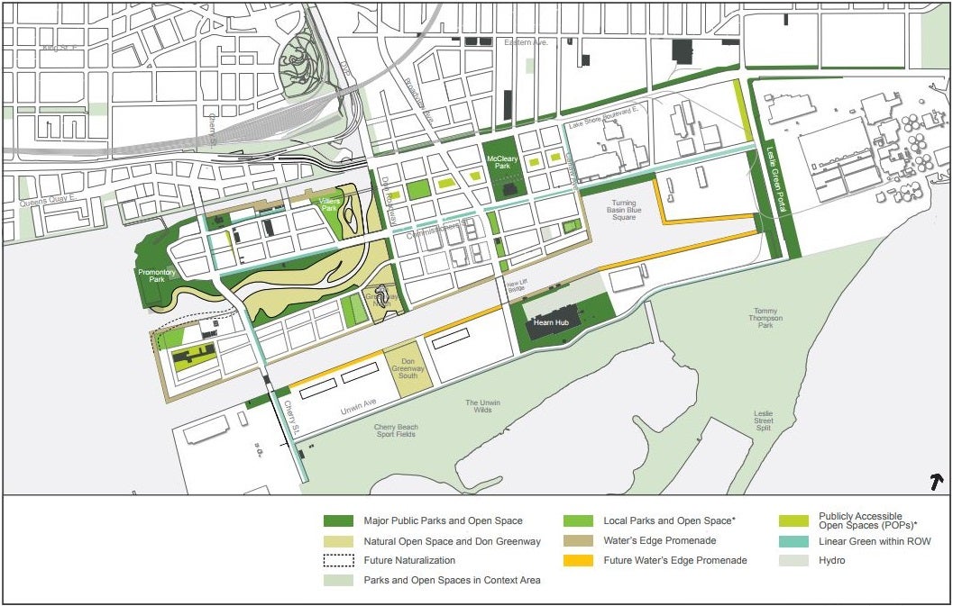
The City of Toronto and Waterfront Toronto presented this conceptual plan for local parks and open spaces to the Port Lands Planning Framework and Villiers Island Precinct Plan Stakeholder Advisory Committee in March 2017. Find these slides and more at portlandsTo.ca.
What won’t change?
Waterfront Toronto and the City of Toronto are developing the Port Lands Planning Framework, which lays out a comprehensive land use and development plan for revitalizing the Port Lands. While new parks, residential, office and commercial buildings will be built, some existing uses will remain. This includes open spaces like Tommy Thompson Park and Cherry Beach, light industrial uses and municipal services, and a film district. Details about that planning process and the related public consultation can be found here.
What will change?
Most of the land in the Port Lands is owned by the City of Toronto or City agencies. Many of the current occupants of the area will have to find a new location for their businesses – a process we expect will be mostly shaped by the leases those businesses have with their landlord. This won’t come as a surprise to affected business operators in the Port Lands. There has been extensive public consultation, including meetings with landowners and users, around the lower Don lands and plans to naturalize the mouth of the Don River dating back to 2003. Since about 2012, we’ve had a landowners and users advisory committee for the Port Lands to make sure we're communicating with businesses in the Port Lands about plans for the area.
What’s happened so far?
The Port Lands Flood Protection and Enabling Infrastructure (PLFPEI) Project has been in the works for over a decade. We have completed a design competition, two Environmental Assessments, business plans, precinct plans and implementation plans. During that time, there has been considerable public consultation and engagement.
This is the culmination of an extensive planning process whose roots can be traced to a public meeting at the Ontario Science Centre in 1989. Here’s the high-level timeline of what happened leading up to the June announcement:
- In 2006, the Don Mouth Naturalization and Port Lands Flood Protection Project Environmental Assessment (DMNP EA) started.
- In 2007, Waterfront Toronto launched an international design competition to create a concept design for the Don River that includes habitat creation and flood protection, and a comprehensive plan for addressing urban design, transportation, naturalization, sustainability and other ecological issues. This involved an extensive public consultation process and a week-long public exhibition. The winning design is by Michael Van Valkenburgh Associates.
- In 2011, Toronto City Council adopted what would later be called the Port Lands Acceleration Initiative (PLAI). The goal of the PLAI was to refine the DMNP EA and develop strategies for accelerating revitalization in the Port Lands. This plan was refined in 2012 and is now known as PLAI 2, which includes the Port Lands Framework Plan, Villiers Island Precinct Plan and Port Lands and South of Eastern Transportation and Servicing Master Plan EA – all of which are nearing completion after several years of consultation.
- In 2014, the Lower Don Lands Master Plan Environmental Assessment was approved.
- In 2015, the DMNP EA was approved.
- In May 2015, work began on the Due Diligence Report for PLFPEI.
- In September 2016, $65 million in tri-government funding was announced for CSLF, which is a component of the larger PLFPEI project.
- In October 2016, the Due Diligence Report for the PLFPEI project was completed, providing governments with additional assurance on the cost of this project, strategies to mitigate the risks, and an implementation strategy and schedule.
- In June 2017, funding was confirmed for the full $1.25 billion needed for PLFPEI. The $65 million already announced for the CSLF project was a portion of the total $1.25 billion.
Why flood protection?
Right now, Toronto’s southeastern downtown is at risk of flooding. There’s currently one outlet for the Don River, a hard right into the Keating Channel. In an extreme weather event, waters from the Don River would overwhelm their east banks and Keating Channel, flooding parts of the Port Lands and surrounding neighbourhoods out to the Leslie Street area.
This animation shows the extent of flooding that would happen in the Port Lands today if a Hurricane Hazel-like event were to occur in the Don River Watershed.
Our plan – which we developed with the City of Toronto and the Toronto and Region Conservation Authority – will create two new outlets for the Don River – including a wide river valley – that will safely convey flood waters into Lake Ontario. The mouth of the Don River will be naturalized, including a new meandering river channel, with levees, wetlands, and meadows.
The flood protection offered by the new, naturalized Don River valley, along with critical city-serving infrastructure, new roads and bridges, public spaces, wetlands and trails will mean this large piece of underused waterfront land is no longer out of reach for Torontonians.
Waterfront Toronto and the City of Toronto open new Aquabella child care centre on Toronto’s waterfront
Tell Us What You Think of the Keating Channel Pedestrian Bridge Design Competition Proposals