City Council Endorses Lower Don Lands Plans

July 9, 2010, Toronto, ON – Toronto City Council has endorsed the award winning plans to transform the Lower Don Lands and renaturalize the mouth of the Don River.
Waterfront Toronto, in conjunction with the City of Toronto and Toronto and Region Conservation, sought Toronto City Council’s authorization to submit all the necessary planning documents to support an Official Plan Amendment for the Lower Don Lands plans. The Official Plan Amendment paves the way for future revitalization of the area including rerouting the river, building flood protection and ultimately building new communities.
Council’s endorsement means the draft Don Mouth Environmental Assessment can be submitted to the Ministry of the Environment for approval under the Environmental Assessment Act, and the Official Plan Amendment and new Zoning By-law can be submitted to the Ministry of Municipal Affairs and Housing and the Ministry of Natural Resources for consistency with provincial flood management policies.
Following approval by the ministries, the Official Plan Amendment and Zoning By-law will go back to City Council in August for final approval. If passed in August, Toronto’s Official Plan will be amended to enshrine the Lower Don Lands plans, ensuring future development in the area is in harmony with the principles and standards of the plan.
“Revitalization of the Lower Don Lands is an integral part of overall waterfront revitalization. The renaturalized Don River will become the centerpiece of a 21st century, mixed-use neighbourhood,” said John Campbell, President and CEO of Waterfront Toronto. “I’m confident the Lower Don Lands will finally realize its potential and become one of the most sought after spots in the City to live, dine, and relax at the water’s edge.”
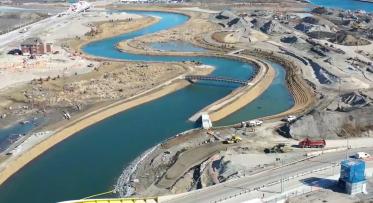
Regeneration and development of the Lower Don Lands has until now been hindered by flood risk, isolation, soil and groundwater contamination and inadequate infrastructure. The plans address and overcome these factors, and will protect more than 230 hectares (568 acres) of land currently at risk due to flooding. The flood mitigation measures in the plan eliminate a potential half-billion dollar flood risk, while simultaneously unlocking the economic development potential for the lands. The plans will transform this post-industrial area into a vibrant mixed-use neighbourhood that combines sustainable city building with major river restoration and naturalization.
The plans were developed as a result of an international design competition in 2007 and were taken through a rigorous technical analysis as part of a comprehensive environmental assessment. Using an integrated design process, the plans skillfully apply ecology to reconnect the city, lake and river, and set the stage for wholesale transformation of the area. The new Lower Don Lands will be a vibrant, mixed-use sustainable community and a sought-after destination to live, work and play.
The planning process for the Lower Don Lands has included extensive community and stakeholder consultation. Numerous meetings with the public, non-profit agencies, community groups, private land owners and other stakeholders were held throughout the process.
In addition to being the recipient of several prestigious international awards, the Lower Don Lands project is also one of 18 projects of the Climate Positive Development Program, U.S. President Bill Clinton's joint Climate Initiative with the U.S. Green Building Council.
- 30 -
The Governments of Canada and Ontario and the City of Toronto created Waterfront Toronto to oversee and lead the renewal of Toronto’s waterfront. Public accessibility, design excellence, sustainable development, economic development and fiscal sustainability are the key drivers of waterfront revitalization.
Media Contact:
Tari Stork, Manager, Project Communications, Waterfront Toronto
Spring Maintenance for the Heart of Love Park
Tell Us What You Think of the Keating Channel Pedestrian Bridge Design Competition Proposals